
Topografische kaart Grenoside
Klik op de kaart om de hoogte weer te geven.
Over deze kaart
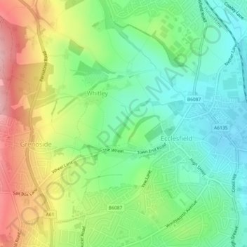
Naam: Topografische kaart Grenoside, hoogte, reliëf.
Gemiddelde hoogte: 121 m
Minimale hoogte: 57 m
Maximale hoogte: 224 m
Andere topografische kaarten
Klik op een kaart om zijn topografie, zijn hoogte en zijn reliëf te bekijken.
Ecclesfield
United Kingdom > England > Sheffield > Whitley
Ecclesfield lies in the north of Sheffield, about 4 miles (7 km) north of the city centre. The suburb of Ecclesfield is in the south-east of the civil parish with the suburbs Chapeltown and High Green to the north, and Grenoside to the west. Its altitude is 60 metres (200 ft) to 120 metres (390 ft) above mean…
Gemiddelde hoogte: 128 m