
Doe een donatie
Rust jezelf uit voor je volgende avontuur:
Als Amazon-partner verdient deze site een commissie op in aanmerking komende aankopen, zonder extra kosten voor jou.
Topografische kaart Sankt Goar
Klik op de kaart om de hoogte weer te geven.
Doe een donatie
Rust jezelf uit voor je volgende avontuur:
Als Amazon-partner verdient deze site een commissie op in aanmerking komende aankopen, zonder extra kosten voor jou.
Sankt Goar
Die Stadt besteht aus der am Rhein liegenden Kernstadt Sankt Goar, den Höhenstadtteilen Biebernheim und Werlau, dem nördlich am Rhein gelegenen Stadtteil Fellen und dem südlich am Rhein gelegenen Stadtteil An der Loreley.
Doe een donatie
Rust jezelf uit voor je volgende avontuur:
Als Amazon-partner verdient deze site een commissie op in aanmerking komende aankopen, zonder extra kosten voor jou.
Over deze kaart
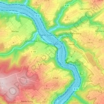
Naam: Topografische kaart Sankt Goar, hoogte, reliëf.
Gemiddelde hoogte: 232 m
Minimale hoogte: 67 m
Maximale hoogte: 423 m
Doe een donatie
Rust jezelf uit voor je volgende avontuur:
Als Amazon-partner verdient deze site een commissie op in aanmerking komende aankopen, zonder extra kosten voor jou.
Andere topografische kaarten
Klik op een kaart om zijn topografie, zijn hoogte en zijn reliëf te bekijken.
Werlau
Deutschland > Rheinland-Pfalz > Rhein-Hunsrück-Kreis > Sankt Goar
Werlau ist ein Stadtteil von Sankt Goar im Rhein-Hunsrück-Kreis in Rheinland-Pfalz. Das Rheinhöhendorf liegt unmittelbar am Steilhang zum Rheintal auf der linken Rheinseite. Der Ort hat etwa 820 Einwohner. Werlau war bis zum 7. Juni 1969 eine eigenständige Gemeinde, die dann im Rahmen einer…
Gemiddelde hoogte: 211 m
Biebernheim
Deutschland > Rheinland-Pfalz > Rhein-Hunsrück-Kreis > Sankt Goar
Biebernheim ist ein Stadtteil von Sankt Goar im Rhein-Hunsrück-Kreis in Rheinland-Pfalz. Das Rheinhöhendorf liegt unmittelbar am Steilhang zum Rheintal auf der linken Rheinseite. Biebernheim war bis zum 7. Juni 1969 eine eigenständige Gemeinde, die dann im Rahmen einer Verwaltungsreform aufgelöst und in…
Gemiddelde hoogte: 214 m
Salzbornhöhe
Deutschland > Rheinland-Pfalz > Rhein-Hunsrück-Kreis > Boppard > Weiler
Gemiddelde hoogte: 242 m
Buchholz
Deutschland > Rheinland-Pfalz > Rhein-Hunsrück-Kreis > Boppard
Buchholz ist seit 1976 der zweitgrößte Ortsbezirk der Stadt Boppard. Die Ortslage liegt auf den Hunsrückhöhen an der Wasserscheide zwischen Rhein und Mosel.
Gemiddelde hoogte: 353 m
Doe een donatie
Rust jezelf uit voor je volgende avontuur:
Als Amazon-partner verdient deze site een commissie op in aanmerking komende aankopen, zonder extra kosten voor jou.
Rheinbay
Deutschland > Rheinland-Pfalz > Rhein-Hunsrück-Kreis > Boppard > Hirzenach > Rheinbay
Gemiddelde hoogte: 350 m
Schanzerkopf
Deutschland > Rheinland-Pfalz > Rhein-Hunsrück-Kreis > Argenthal
Gemiddelde hoogte: 548 m
Waldsiedlung Römerstraße
Deutschland > Rheinland-Pfalz > Rhein-Hunsrück-Kreis > Rheinböllen
Gemiddelde hoogte: 441 m
Doe een donatie
Rust jezelf uit voor je volgende avontuur:
Als Amazon-partner verdient deze site een commissie op in aanmerking komende aankopen, zonder extra kosten voor jou.
Dellhofen
Deutschland > Rheinland-Pfalz > Rhein-Hunsrück-Kreis > Oberwesel
Das Rheinhöhendorf Dellhofen ist ein Stadtteil und ein Ortsbezirk der Stadt Oberwesel im Rhein-Hunsrück-Kreis in Rheinland-Pfalz.
Gemiddelde hoogte: 273 m
Wohnroth
Deutschland > Rheinland-Pfalz > Rhein-Hunsrück-Kreis
Die Ortschaft Wohnroth, im örtlichen Dialekt Woord, liegt in einer Hanglage am Beginn des Wohnrother Tales, das an der Burg Balduinseck endet. Der Ort kann nur über Land- und Kreisstraßen von der ca. 5 km entfernten Hunsrückhöhenstraße erreicht werden.
Gemiddelde hoogte: 404 m
Werlauer Pilz
Deutschland > Rheinland-Pfalz > Rhein-Hunsrück-Kreis > Sankt Goar > Biebernheim
Gemiddelde hoogte: 170 m
Doe een donatie
Rust jezelf uit voor je volgende avontuur:
Als Amazon-partner verdient deze site een commissie op in aanmerking komende aankopen, zonder extra kosten voor jou.
Fleckertshöhe
Deutschland > Rheinland-Pfalz > Rhein-Hunsrück-Kreis > Boppard
Fleckertshöhe von Nordosten
Gemiddelde hoogte: 413 m
St. Goar-Fellen
Deutschland > Rheinland-Pfalz > Rhein-Hunsrück-Kreis > Sankt Goar
Gemiddelde hoogte: 208 m
Doe een donatie
Rust jezelf uit voor je volgende avontuur:
Als Amazon-partner verdient deze site een commissie op in aanmerking komende aankopen, zonder extra kosten voor jou.
Langscheid
Deutschland > Rheinland-Pfalz > Rhein-Hunsrück-Kreis > Oberwesel
Über die Jahrhunderte variierte der Ortsname leicht – es finden sich nach der ersten Erwähnung 1253 als in Langesceider bach noch verschiedene Abwandlungen, bis im Jahr 1788 erstmals das heutige „Langscheid“ erscheint. Der Ortsname leitet sich von mittelhochdeutsch langen scheit = „beim langen…
Gemiddelde hoogte: 263 m
Holzfeld
Deutschland > Rheinland-Pfalz > Rhein-Hunsrück-Kreis > Boppard > Holzfeld
Der Name des Ortes stammt aus dem mittelhochdeutsch: Hals = fortlaufende schmale Höhe. Somit leitet sich der Name Holzfeld von der geographischen Lage ab.
Gemiddelde hoogte: 283 m
Schnellbach
Deutschland > Rheinland-Pfalz > Rhein-Hunsrück-Kreis > Schnellbach
Gemiddelde hoogte: 423 m
Salzbornhöhe
Deutschland > Rheinland-Pfalz > Rhein-Hunsrück-Kreis > Boppard > Weiler
Gemiddelde hoogte: 242 m
Doe een donatie
Rust jezelf uit voor je volgende avontuur:
Als Amazon-partner verdient deze site een commissie op in aanmerking komende aankopen, zonder extra kosten voor jou.