
Doe een donatie
Rust jezelf uit voor je volgende avontuur:
Als Amazon-partner verdient deze site een commissie op in aanmerking komende aankopen, zonder extra kosten voor jou.
Topografische kaart Roccasecca
Klik op de kaart om de hoogte weer te geven.
Doe een donatie
Rust jezelf uit voor je volgende avontuur:
Als Amazon-partner verdient deze site een commissie op in aanmerking komende aankopen, zonder extra kosten voor jou.
Roccasecca
The history of Roccasecca is tightly bound to its strategic position, a "dry rocca" at the entrance to two narrow defiles that give access to the Valle di Comino below the slopes of Monte Asprano, whose elevation at 553 metres (1,814 ft) provides a natural position to control the wide Valle del Liri. Remains of archaic perimeter walling attest to an early fortified presence around the site. Roccasecca served as a way station for ancient Roman legions and invading armies crossing the River Melfa, spanned by three ancient bridges there, remains of which still exist. However, the Medieval commune truly began in the early Middle Ages.
Doe een donatie
Rust jezelf uit voor je volgende avontuur:
Als Amazon-partner verdient deze site een commissie op in aanmerking komende aankopen, zonder extra kosten voor jou.
Over deze kaart
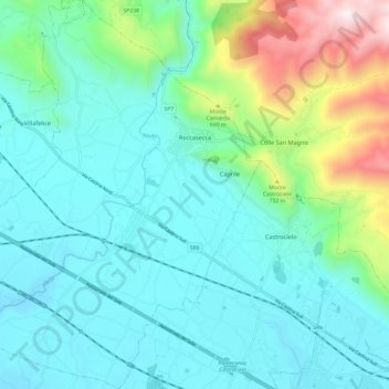
Naam: Topografische kaart Roccasecca, hoogte, reliëf.
Locatie: Roccasecca, Frosinone, Lazio, 03038, Italy (41.49380 13.58465 41.58416 13.68777)
Gemiddelde hoogte: 327 m
Minimale hoogte: 72 m
Maximale hoogte: 1.306 m
Doe een donatie
Rust jezelf uit voor je volgende avontuur:
Als Amazon-partner verdient deze site een commissie op in aanmerking komende aankopen, zonder extra kosten voor jou.
Andere topografische kaarten
Klik op een kaart om zijn topografie, zijn hoogte en zijn reliëf te bekijken.
Doe een donatie
Rust jezelf uit voor je volgende avontuur:
Als Amazon-partner verdient deze site een commissie op in aanmerking komende aankopen, zonder extra kosten voor jou.