
Topografische kaart Paso Robles
Interactieve kaart
Klik op de kaart om de hoogte weer te geven.
Over deze kaart
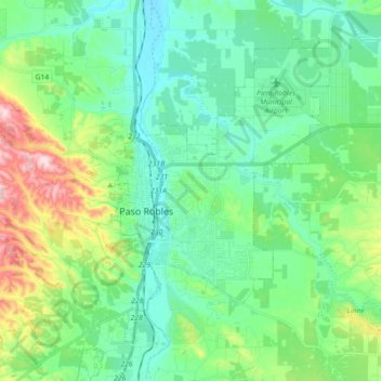
Naam: Topografische kaart Paso Robles, hoogte, reliëf.
Gemiddelde hoogte: 298 m
Minimale hoogte: 193 m
Maximale hoogte: 628 m
The topography of the area consists of gentle rolling hills on the eastern half of the city, and foothill peaks, which rise in elevation to the Santa Lucia Coastal Range on the west, which are all blanketed in the Californian chaparral environment, which is mainly dry grassland and oak woodland. Paso Robles sits on the eastern foothills of the Santa Lucia Coastal Mountain Range, which lies directly to the west of the city, and runs in a north–south direction, starting at Monterey, then runs south to its terminus in the San Luis Obispo area. The city is located at the southern end of the fertile Salinas River Valley, which is centered in between the Temblor Range (including the San Andreas Fault), which lie about 28 mi (45 km) to the east, and the Santa Lucia Coastal Range, which lies directly west, rising up from the city's western border. Paso Robles sits at the border where northern San Luis Obispo County and southern Monterey County meet, and is situated roughly 24 mi (39 km) inland from the Pacific Ocean.
Andere topografische kaarten
Klik op een kaart om zijn topografie, zijn hoogte en zijn reliëf te bekijken.
Atascadero
United States > California > San Luis Obispo County
Atascadero, San Luis Obispo County, California, United States
Gemiddelde hoogte: 337 m
San Luis Obispo
United States > California > San Luis Obispo County
San Luis Obispo, San Luis Obispo County, California, United States
Gemiddelde hoogte: 133 m
Shandon
United States > California > San Luis Obispo County
Shandon, San Luis Obispo County, California, 93461, United States
Gemiddelde hoogte: 345 m
Nipomo
United States > California > San Luis Obispo County
Nipomo, San Luis Obispo County, California, 93444, United States
Gemiddelde hoogte: 107 m
Laguna Lake
United States > California > San Luis Obispo County > San Luis Obispo
Laguna Lake, San Luis Obispo, San Luis Obispo County, CAL Fire Southern Region, California, 93405, United States
Gemiddelde hoogte: 63 m
Santa Lucia Range
United States > California > San Luis Obispo County
Santa Lucia Range, San Luis Obispo County, CAL Fire Southern Region, California, United States
Gemiddelde hoogte: 347 m
Arroyo Grande
United States > California > San Luis Obispo County > Arroyo Grande > Arroyo Grande
Arroyo Grande, San Luis Obispo County, California, 93420-2419, United States
Gemiddelde hoogte: 56 m
San Andreas Fault
United States > California > San Luis Obispo County
San Andreas Fault, San Luis Obispo County, CAL Fire Southern Region, California, United States
Gemiddelde hoogte: 681 m
Grover Beach
United States > California > San Luis Obispo County
Grover Beach, San Luis Obispo County, California, 93433, United States
Gemiddelde hoogte: 21 m
Los Osos
United States > California > San Luis Obispo County
Los Osos, San Luis Obispo County, California, 93402, United States
Gemiddelde hoogte: 65 m
Rocky Butte
United States > California > San Luis Obispo County
Rocky Butte, San Luis Obispo County, CAL Fire Southern Region, California, United States
Gemiddelde hoogte: 782 m
Grover Beach
United States > California > San Luis Obispo County > Grover Beach > Grover Beach
Grover Beach, San Luis Obispo County, California, 93433, United States
Gemiddelde hoogte: 36 m
Creston
United States > California > San Luis Obispo County
Creston, San Luis Obispo County, California, United States
Gemiddelde hoogte: 356 m
Morro Bay
United States > California > San Luis Obispo County > Morro Bay > Morro Bay
Morro Bay, San Luis Obispo County, California, 93442, United States
Gemiddelde hoogte: 36 m
San Miguel
United States > California > San Luis Obispo County > San Miguel
San Miguel, San Luis Obispo County, CAL Fire Southern Region, California, United States
Gemiddelde hoogte: 221 m
Varian Ranch
United States > California > San Luis Obispo County
Varian Ranch, San Luis Obispo County, CAL Fire Southern Region, California, 93420, United States
Gemiddelde hoogte: 160 m
Templeton
United States > California > San Luis Obispo County
Templeton, San Luis Obispo County, California, 93465, United States
Gemiddelde hoogte: 260 m
Pine Slope
United States > California > San Luis Obispo County
Pine Slope, San Luis Obispo County, CAL Fire Southern Region, California, United States
Gemiddelde hoogte: 391 m
Santa Margarita
United States > California > San Luis Obispo County
Santa Margarita, San Luis Obispo County, California, United States
Gemiddelde hoogte: 333 m
San Luis Obispo
United States > California > San Luis Obispo County > San Luis Obispo
San Luis Obispo, San Luis Obispo County, California, 93410, United States
Gemiddelde hoogte: 254 m
Arroyo Grande
United States > California > San Luis Obispo County
Arroyo Grande, San Luis Obispo County, CAL Fire Southern Region, California, United States
Gemiddelde hoogte: 52 m
Avila Beach
United States > California > San Luis Obispo County
Avila Beach, San Luis Obispo County, California, 93424, United States
Gemiddelde hoogte: 46 m
alluvial fan
United States > California > San Luis Obispo County
alluvial fan, San Luis Obispo County, California, United States
Gemiddelde hoogte: 337 m
Morro Bay
United States > California > San Luis Obispo County
Morro Bay, San Luis Obispo County, California, 93442, United States
Gemiddelde hoogte: 54 m
Oceano
United States > California > San Luis Obispo County
Oceano, San Luis Obispo County, CAL Fire Southern Region, California, 93421, United States
Gemiddelde hoogte: 16 m
Cambria
United States > California > San Luis Obispo County > Lodge Hill
Cambria, Fiscalini Ranch Preserve, Lodge Hill, San Luis Obispo County, California, United States
Gemiddelde hoogte: 52 m
Cayucos
United States > California > San Luis Obispo County
Cayucos, San Luis Obispo County, California, 93430, United States
Gemiddelde hoogte: 47 m
San Simeon
United States > California > San Luis Obispo County
San Simeon, San Luis Obispo County, California, 93452, United States
Gemiddelde hoogte: 31 m