
Topografische kaart Wind River Range
Interactieve kaart
Klik op de kaart om de hoogte weer te geven.
Over deze kaart
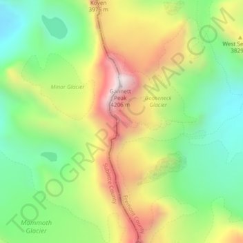
Naam: Topografische kaart Wind River Range, hoogte, reliëf.
Gemiddelde hoogte: 3.706 m
Minimale hoogte: 3.338 m
Maximale hoogte: 4.208 m
Andere topografische kaarten
Klik op een kaart om zijn topografie, zijn hoogte en zijn reliëf te bekijken.
Yellowstone Caldera Supervolcano
United States of America > Wyoming
Yellowstone Caldera Supervolcano, Teton County, Wyoming, United States of America
Gemiddelde hoogte: 2.530 m
Cedar Rim
United States of America > Wyoming > Riverton
Cedar Rim, Sand Draw Road, Riverton, Fremont County, Wyoming, United States of America
Gemiddelde hoogte: 2.131 m
Upton
United States of America > Wyoming > Upton
Upton, Weston County, Wyoming, United States of America
Gemiddelde hoogte: 1.301 m
Red Butte
United States of America > Wyoming > Red Butte
Red Buttes Village, Red Butte, Natrona County, Wyoming, 82604, United States of America
Gemiddelde hoogte: 1.605 m
Devils Tower
United States of America > Wyoming
Devils Tower, Crook County, Wyoming, 82714, United States of America
Gemiddelde hoogte: 1.236 m
Shoshone Geyser
United States of America > Wyoming
Shoshone Geyser, Shoshone Lake, Teton County, Wyoming, United States of America
Gemiddelde hoogte: 2.416 m
Opal
United States of America > Wyoming > Opal
Opal, Lincoln County, Wyoming, United States of America
Gemiddelde hoogte: 2.048 m
Phelps Lake
United States of America > Wyoming > Teton Village
Phelps Lake, Aspen Ridge Trail, Teton Village, Teton County, Wyoming, 83025, United States of America
Gemiddelde hoogte: 2.084 m