
Topografische kaart Bayview
Interactieve kaart
Klik op de kaart om de hoogte weer te geven.
Over deze kaart
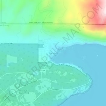
Naam: Topografische kaart Bayview, hoogte, reliëf.
Locatie: Bayview, Kootenai County, Idaho, United States (47.96033 -116.58043 48.00033 -116.54043)
Gemiddelde hoogte: 733 m
Minimale hoogte: 616 m
Maximale hoogte: 1.195 m
Bayview is an unincorporated community in the northwest United States, located in Kootenai County, Idaho, north of Coeur d'Alene. On the southwest shore of Lake Pend Oreille, Bayview is seven miles (11 km) east-northeast of Athol. The community is served by State Highway 54 and a post office with ZIP code 83803; its approximate elevation is 2,100 feet (640 m) above sea level. Nearby is Farragut State Park, formerly the Farragut Naval Training Station, a major training facility during World War II.
Andere topografische kaarten
Klik op een kaart om zijn topografie, zijn hoogte en zijn reliëf te bekijken.
Coeur d'Alene
United States > Idaho > Kootenai County
Coeur d'Alene, Kootenai County, Idaho, United States
Gemiddelde hoogte: 719 m
Athol
United States > Idaho > Kootenai County
Athol, Kootenai County, Idaho, United States
Gemiddelde hoogte: 733 m
Post Falls
United States > Idaho > Kootenai County
Post Falls, Kootenai County, Idaho, 83854, United States
Gemiddelde hoogte: 710 m
Hayden
United States > Idaho > Kootenai County
Hayden, Kootenai County, Idaho, 83835, United States
Gemiddelde hoogte: 717 m
Rathdrum
United States > Idaho > Kootenai County
Rathdrum, Kootenai County, Idaho, 83858, United States
Gemiddelde hoogte: 701 m