
Topografische kaart Shercock
Interactieve kaart
Klik op de kaart om de hoogte weer te geven.
Over deze kaart
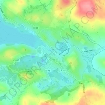
Naam: Topografische kaart Shercock, hoogte, reliëf.
Gemiddelde hoogte: 117 m
Minimale hoogte: 85 m
Maximale hoogte: 176 m
The region is known as "Drumlin Country" owing to its topography of small hills and lakes formed at the end of the last ice age. County Cavan borders County Fermanagh and County Monaghan. Together, they form the colloquially named "Drumlin County". Shercock lies on the border between County Cavan and County Monaghan.
Andere topografische kaarten
Klik op een kaart om zijn topografie, zijn hoogte en zijn reliëf te bekijken.
Kilnaleck
Kilnaleck, Ballyjamesduff Municipal District, County Cavan, A82 X567, Ireland
Gemiddelde hoogte: 114 m
Callanagh Lower
Callanagh Lower, Drumlumman ED, Ballyjamesduff Municipal District, County Cavan, Ulster, Ireland
Gemiddelde hoogte: 85 m
Virginia
Virginia, Virginia ED, Ballyjamesduff Municipal District, County Cavan, Ireland
Gemiddelde hoogte: 98 m
Crossdoney
Crossdoney, Ballyjamesduff Municipal District, County Cavan, H12 K727, Ireland
Gemiddelde hoogte: 67 m
Bailieborough
Bailieborough, Bailieborough ED, Bailieborough-Cootehill Municipal District, County Cavan, A82 NX86, Ireland
Gemiddelde hoogte: 162 m
Mount Nugent
Mount Nugent, Ballyjamesduff Municipal District, County Cavan, Ulster, Ireland
Gemiddelde hoogte: 74 m
Ballyjamesduff
Ballyjamesduff, Ballyjamesduff Municipal District, County Cavan, Ulster, A82 CT95, Ireland
Gemiddelde hoogte: 118 m
Ballyconnell
Ballyconnell, Ballyconnell ED, Cavan-Belturbet Municipal District, County Cavan, Ulster, H14 EC99, Ireland
Gemiddelde hoogte: 68 m
Cootehill
Cootehill, Bailieborough-Cootehill Municipal District, County Cavan, Ulster, Ireland
Gemiddelde hoogte: 89 m
Cornafean
Cornafean, Ballyjamesduff Municipal District, County Cavan, Ulster, Ireland
Gemiddelde hoogte: 82 m
Killashandra
Killashandra, Killashandra ED, Cavan-Belturbet Municipal District, County Cavan, Ulster, Ireland
Gemiddelde hoogte: 62 m
Loch Gowna (Scrabby)
Loch Gowna (Scrabby), Scrabby ED, Ballyjamesduff Municipal District, County Cavan, Ulster, Ireland
Gemiddelde hoogte: 80 m
Snugborough
Snugborough, Ballyconnell ED, Cavan-Belturbet Municipal District, County Cavan, Ulster, Ireland
Gemiddelde hoogte: 174 m
Tullycoe
Tullycoe, Larah North ED, Bailieborough-Cootehill Municipal District, County Cavan, Ulster, Ireland
Gemiddelde hoogte: 96 m
Togher or Danesfort Demesne
Togher or Danesfort Demesne, Killykeen ED, Cavan-Belturbet Municipal District, County Cavan, Ulster, Ireland
Gemiddelde hoogte: 64 m
Corfad
Corfad, Stradone ED, Bailieborough-Cootehill Municipal District, County Cavan, Ireland
Gemiddelde hoogte: 130 m
Lisdaran
Lisdaran, Cavan Rural ED, Cavan-Belturbet Municipal District, County Cavan, Ulster, Ireland
Gemiddelde hoogte: 73 m
Cormeen
Cormeen, Larah South ED, Bailieborough-Cootehill Municipal District, County Cavan, Ulster, Ireland
Gemiddelde hoogte: 133 m
Monaghanoose
Monaghanoose, Drumanespick ED, Bailieborough-Cootehill Municipal District, County Cavan, Ireland
Gemiddelde hoogte: 140 m
Bailieborough
Bailieborough, Bailieborough-Cootehill Municipal District, County Cavan, Ulster, A82 NX86, Ireland
Gemiddelde hoogte: 163 m
Cleffin
Cleffin, Killinkere ED, Bailieborough-Cootehill Municipal District, County Cavan, Ulster, Ireland
Gemiddelde hoogte: 128 m
Bailieborough
Ireland > County Cavan > Bailieborough
Bailieborough, Bailieborough-Cootehill Municipal District, County Cavan, A82 NX86, Ireland
Gemiddelde hoogte: 169 m
Seefin
Seefin, Drumanespick ED, Bailieborough-Cootehill Municipal District, County Cavan, Ireland
Gemiddelde hoogte: 194 m
Kilnavert
Kilnavert, Ballymagauran ED, Cavan-Belturbet Municipal District, County Cavan, Ireland
Gemiddelde hoogte: 68 m
Killaghaduff
Killaghaduff, Swanlinbar ED, Cavan-Belturbet Municipal District, County Cavan, Ireland
Gemiddelde hoogte: 91 m
Drumgart
Drumgart, Ardue ED, Cavan-Belturbet Municipal District, County Cavan, Ireland
Gemiddelde hoogte: 55 m
Cornamucklagh
Ireland > County Cavan > Cornamucklagh
Cornamucklagh, Crossdoney ED, Ballyjamesduff Municipal District, County Cavan, H12K727, Ireland
Gemiddelde hoogte: 61 m
Bailieborough-Cootehill Municipal District
Bailieborough-Cootehill Municipal District, County Cavan, Ulster, Ireland
Gemiddelde hoogte: 122 m
Carrickallen
Carrickallen, Larah North ED, Bailieborough-Cootehill Municipal District, County Cavan, Ireland
Gemiddelde hoogte: 185 m
Dunaree
Dunaree, Kingscourt ED, Bailieborough-Cootehill Municipal District, County Cavan, Ireland
Gemiddelde hoogte: 115 m
Laraweehan
Laraweehan, Knappagh ED, Bailieborough-Cootehill Municipal District, County Cavan, Ireland
Gemiddelde hoogte: 104 m
Drumlane
Drumlane, Drung ED, Bailieborough-Cootehill Municipal District, County Cavan, Ireland
Gemiddelde hoogte: 93 m
Cavan-Belturbet Municipal District
Cavan-Belturbet Municipal District, County Cavan, Ulster, Ireland
Gemiddelde hoogte: 111 m
Glangevlin
Glangevlin, Cavan-Belturbet Municipal District, County Cavan, Ulster, Ireland
Gemiddelde hoogte: 185 m
Kilcogy
Kilcogy, Ballyjamesduff Municipal District, County Cavan, Ulster, Ireland
Gemiddelde hoogte: 89 m