
Topografische kaart Mount Zion
Interactieve kaart
Klik op de kaart om de hoogte weer te geven.
Over deze kaart
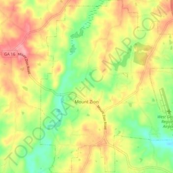
Naam: Topografische kaart Mount Zion, hoogte, reliëf.
Locatie: Mount Zion, Carroll County, Georgia, United States (33.60884 -85.20707 33.67039 -85.14784)
Gemiddelde hoogte: 356 m
Minimale hoogte: 307 m
Maximale hoogte: 404 m
Andere topografische kaarten
Klik op een kaart om zijn topografie, zijn hoogte en zijn reliëf te bekijken.
Carrollton
United States > Georgia > Carroll County
Carrollton, Carroll County, Georgia, United States
Gemiddelde hoogte: 329 m
Roopville
United States > Georgia > Carroll County
Roopville, Carroll County, Georgia, United States
Gemiddelde hoogte: 350 m
Bowdon
United States > Georgia > Carroll County
Bowdon, Carroll County, Georgia, 30108, United States
Gemiddelde hoogte: 319 m
Ithaca
United States > Georgia > Carroll County
Ithaca, Carroll County, Georgia, United States
Gemiddelde hoogte: 342 m
Villa Rica
United States > Georgia > Carroll County
Villa Rica, Carroll County, Georgia, 30180, United States
Gemiddelde hoogte: 338 m
Lowell
United States > Georgia > Carroll County
Lowell, Carroll County, Georgia, United States
Gemiddelde hoogte: 304 m
Temple
United States > Georgia > Carroll County
Temple, Carroll County, Georgia, United States
Gemiddelde hoogte: 346 m
Whitesburg
United States > Georgia > Carroll County
Whitesburg, Carroll County, Georgia, United States
Gemiddelde hoogte: 249 m