
Topografische kaart Big Bend National Park
Interactieve kaart
Klik op de kaart om de hoogte weer te geven.
Over deze kaart
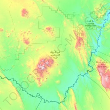
Naam: Topografische kaart Big Bend National Park, hoogte, reliëf.
Gemiddelde hoogte: 934 m
Minimale hoogte: 490 m
Maximale hoogte: 2.330 m
Big Bend National Park is an American national park located in West Texas, bordering Mexico. The park has national significance as the largest protected area of Chihuahuan Desert topography and ecology in the United States, and was named after a large bend in the Rio Grande/Río Bravo. The park protects more than 1,200 species of plants, more than 450 species of birds, 56 species of reptiles, and 75 species of mammals. Additional park activities include scenic drives, programs led by Big Bend park rangers, and stargazing.
Andere topografische kaarten
Klik op een kaart om zijn topografie, zijn hoogte en zijn reliëf te bekijken.
Big Bend National Park
United States > Texas > Brewster County
Big Bend National Park, Brewster County, Texas, 79834, United States
Gemiddelde hoogte: 934 m
Santiago Peak
United States > Texas > Brewster County
Santiago Peak, Brewster County, Texas, United States
Gemiddelde hoogte: 1.525 m
Alpine
United States > Texas > Brewster County
Alpine, Brewster County, Texas, United States
Gemiddelde hoogte: 1.373 m