
Topografische kaart Thoreau
Interactieve kaart
Klik op de kaart om de hoogte weer te geven.
Over deze kaart
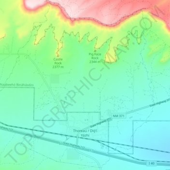
Naam: Topografische kaart Thoreau, hoogte, reliëf.
Locatie: Thoreau, McKinley County, New Mexico, 87323, United States (35.38735 -108.27384 35.45973 -108.18253)
Gemiddelde hoogte: 2.253 m
Minimale hoogte: 2.138 m
Maximale hoogte: 2.591 m
Thoreau is located at an altitude of approximately 2,200 meters (7,200 feet) above sea level, and 8 kilometers (5.0 mi) east of the continental divide. Thoreau is located in a broad valley beneath a large escarpment of Entrada sandstone, which marks the southern boundary of the Colorado Plateau to the north. Mount Powell and Castle Rock are landmarks along this escarpment adjacent to Thoreau. The Zuñi Mountains are to the south.
Andere topografische kaarten
Klik op een kaart om zijn topografie, zijn hoogte en zijn reliëf te bekijken.
Gallup
United States > New Mexico > McKinley County
Gallup, McKinley County, New Mexico, 87301, United States
Gemiddelde hoogte: 2.067 m
Zuni Pueblo
United States > New Mexico > McKinley County
Zuni Pueblo, McKinley County, New Mexico, 87327, United States
Gemiddelde hoogte: 1.931 m
Littlewater
United States > New Mexico > McKinley County
Littlewater, Eastern Navajo Agency, McKinley County, New Mexico, United States
Gemiddelde hoogte: 2.082 m
Crownpoint
United States > New Mexico > McKinley County
Crownpoint, Eastern Navajo Agency, McKinley County, New Mexico, 87313, United States
Gemiddelde hoogte: 2.099 m
Pinedale
United States > New Mexico > McKinley County
Pinedale, Eastern Navajo Agency, McKinley County, New Mexico, United States
Gemiddelde hoogte: 2.154 m
Navajo
United States > New Mexico > McKinley County
Navajo, Fort Defiance Agency, McKinley County, New Mexico, 87328, United States
Gemiddelde hoogte: 2.203 m
Prewitt Lake
United States > New Mexico > McKinley County
Prewitt Lake, McKinley County, New Mexico, United States
Gemiddelde hoogte: 2.393 m
Nahodishgish
United States > New Mexico > McKinley County
Nahodishgish, Eastern Navajo Agency, McKinley County, New Mexico, United States
Gemiddelde hoogte: 2.061 m
Continental Divide
United States > New Mexico > McKinley County
Continental Divide, McKinley County, New Mexico, 87312, United States
Gemiddelde hoogte: 2.221 m
Ramah
United States > New Mexico > McKinley County
Ramah, Eastern Navajo Agency, McKinley County, New Mexico, United States
Gemiddelde hoogte: 2.184 m
Eastern Navajo Agency
United States > New Mexico > McKinley County
Eastern Navajo Agency, McKinley County, New Mexico, United States
Gemiddelde hoogte: 2.005 m
Pueblo Pintado
United States > New Mexico > McKinley County > Pueblo Pintado
Pueblo Pintado, Navajo Route 7008, Pueblo Pintado, Eastern Navajo Agency, McKinley County, New Mexico, United States
Gemiddelde hoogte: 1.981 m
Smith Lake
United States > New Mexico > McKinley County
Smith Lake, Eastern Navajo Agency, McKinley County, New Mexico, United States
Gemiddelde hoogte: 2.221 m
Tinian
United States > New Mexico > McKinley County
Tinian, Eastern Navajo Agency, McKinley County, New Mexico, United States
Gemiddelde hoogte: 2.014 m