
Topografische kaart Hot Springs National Park
Interactieve kaart
Klik op de kaart om de hoogte weer te geven.
Over deze kaart
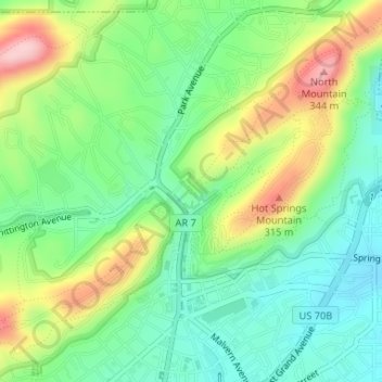
Naam: Topografische kaart Hot Springs National Park, hoogte, reliëf.
Gemiddelde hoogte: 227 m
Minimale hoogte: 158 m
Maximale hoogte: 346 m
The National Park Service exercises no control or supervision over any matters connected with the city. The city starts on the other side of Central Avenue from Bathhouse Row. Its development has extended beyond the narrow valley in which the springs are located, spreading out over the open plain to the south and east. The climate is good throughout the year. The elevation of the city is 600 feet (180 m) above sea level, with surrounding hills rising another 600 feet. In the first half of the 20th century, the city operated primarily as a summer resort, but hotels have now long stayed open during the winter due to many northerly patrons coming to escape the winter cold.
Andere topografische kaarten
Klik op een kaart om zijn topografie, zijn hoogte en zijn reliëf te bekijken.
Piney
United States > Arkansas > Garland County > Hot Springs
Piney, Hot Springs, Garland County, Arkansas, United States
Gemiddelde hoogte: 146 m
Lake Hamilton
United States > Arkansas > Garland County > Hot Springs
Lake Hamilton, Hot Springs, Garland County, Arkansas, United States
Gemiddelde hoogte: 130 m
Hot Springs
United States > Arkansas > Garland County > Hot Springs
Hot Springs, Garland County, Arkansas, 71901, United States
Gemiddelde hoogte: 187 m