
Topografische kaart Boise
Interactieve kaart
Klik op de kaart om de hoogte weer te geven.
Over deze kaart
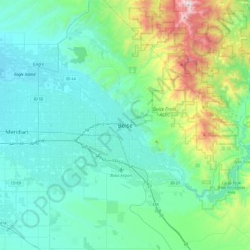
Naam: Topografische kaart Boise, hoogte, reliëf.
Locatie: Boise, Ada County, Idaho, 83701, United States (43.45662 -116.36089 43.77662 -116.04089)
Gemiddelde hoogte: 1.040 m
Minimale hoogte: 762 m
Maximale hoogte: 2.303 m
Boise (locally /ˈbɔɪsi/ BOY-see) is the capital and most populous city of the U.S. state of Idaho and is the county seat of Ada County. As of the 2020 census, there were 235,684 people residing in the city. On the Boise River in southwestern Idaho, it is 41 miles (66 km) east of the Oregon border and 110 miles (177 km) north of the Nevada border. The downtown area's elevation is 2,704 feet (824 m) above sea level.
Andere topografische kaarten
Klik op een kaart om zijn topografie, zijn hoogte en zijn reliëf te bekijken.
Garden City
United States > Idaho > Ada County
Garden City, Ada County, Idaho, United States
Gemiddelde hoogte: 852 m
Hidden Springs
United States > Idaho > Ada County
Hidden Springs, Ada County, Idaho, United States
Gemiddelde hoogte: 912 m
Boise
United States > Idaho > Ada County
Boise, Ada County, Idaho, United States
Gemiddelde hoogte: 974 m
Swan Falls
United States > Idaho > Ada County
Swan Falls, Ada County, Idaho, United States
Gemiddelde hoogte: 842 m
Eagle Island State Park
United States > Idaho > Ada County > Eagle
Eagle Island State Park, Eagle, Ada County, Idaho, 83616, United States
Gemiddelde hoogte: 773 m
Meridian
United States > Idaho > Ada County
Meridian, Ada County, Idaho, United States
Gemiddelde hoogte: 802 m
Eagle
United States > Idaho > Ada County
Eagle, Ada County, Idaho, 83616, United States
Gemiddelde hoogte: 851 m
Lucky Peak
United States > Idaho > Ada County
Lucky Peak, Ada County, Idaho, United States
Gemiddelde hoogte: 1.585 m
Star
United States > Idaho > Ada County
Star, Ada County, Idaho, 83669, United States
Gemiddelde hoogte: 765 m
Kuna
United States > Idaho > Ada County
Kuna, Ada County, Idaho, United States
Gemiddelde hoogte: 830 m