
Topografische kaart Fayetteville
Interactieve kaart
Klik op de kaart om de hoogte weer te geven.
Over deze kaart
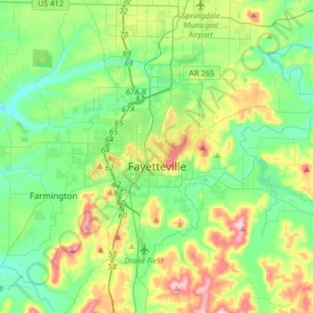
Naam: Topografische kaart Fayetteville, hoogte, reliëf.
Locatie: Fayetteville, Washington County, Arkansas, United States (35.98936 -94.29778 36.14893 -94.02671)
Gemiddelde hoogte: 401 m
Minimale hoogte: 325 m
Maximale hoogte: 581 m
...yet I venture the assertion that nowhere in said country—or for that matter, in any part of the state—could be found a lovelier elevation, or a lovelier grove of graceful oaks, or a more commanding view, or, in fine, a spot better suited and adapted for the purposes designated than the one chosen for said University [of Arkansas] site and farm.
Andere topografische kaarten
Klik op een kaart om zijn topografie, zijn hoogte en zijn reliëf te bekijken.
Prairie Grove
United States > Arkansas > Washington County
Prairie Grove, Washington County, Arkansas, 72753, United States
Gemiddelde hoogte: 356 m
Springdale
United States > Arkansas > Washington County > Springdale
Springdale, Washington County, Arkansas, 72764, United States
Gemiddelde hoogte: 388 m
Springdale
United States > Arkansas > Washington County
Springdale, Washington County, Arkansas, United States
Gemiddelde hoogte: 398 m