
Topografische kaart Lawson
Interactieve kaart
Klik op de kaart om de hoogte weer te geven.
Over deze kaart
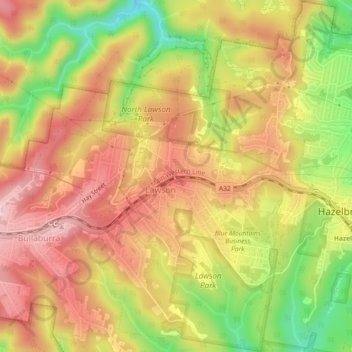
Naam: Topografische kaart Lawson, hoogte, reliëf.
Gemiddelde hoogte: 684 m
Minimale hoogte: 535 m
Maximale hoogte: 790 m
In 1931, the Railway Department agreed to supply electricity to the Blue Mountains Shire Council. Power lines were constructed between Blackheath and Lawson, accompanied by a maintenance track. The authorities then decided to promote the maintenance track as a walking trail; it became known as Bruce's Walk, after the surveyor who planned it. The track later became neglected and forgotten, until it was rediscovered and improved by bushwalkers in the 1980s. It can now be followed from Medlow Bath to the north side of Lawson, although it is not shown on the relevant topographic map.
Andere topografische kaarten
Klik op een kaart om zijn topografie, zijn hoogte en zijn reliëf te bekijken.
Dantes Glen
Australia > New South Wales > Sydney > Lawson
Dantes Glen, Lawson, Sydney, Blue Mountains City Council, New South Wales, 2783, Australia
Gemiddelde hoogte: 689 m
Sydney Rock
Australia > New South Wales > Sydney > Lawson
Sydney Rock, Great Western Highway, Lawson, Sydney, Blue Mountains City Council, New South Wales, 2783, Australia
Gemiddelde hoogte: 671 m