
Topografische kaart Coles Bay
Interactieve kaart
Klik op de kaart om de hoogte weer te geven.
Over deze kaart
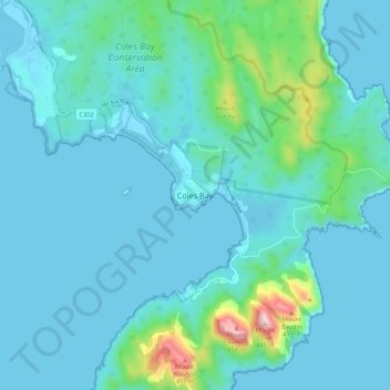
Naam: Topografische kaart Coles Bay, hoogte, reliëf.
Locatie: Coles Bay, Tasmania, 7251, Australia (-42.16522 148.24854 -42.08522 148.32854)
Gemiddelde hoogte: 57 m
Minimale hoogte: -1 m
Maximale hoogte: 476 m
Andere topografische kaarten
Klik op een kaart om zijn topografie, zijn hoogte en zijn reliëf te bekijken.
Wineglass Bay
Australia > Tasmania > Coles Bay
Wineglass Bay, Isthmus Track, Coles Bay, Tasmania, 7251, Australia
Gemiddelde hoogte: 45 m