
Topografische kaart Mieres
Interactieve kaart
Klik op de kaart om de hoogte weer te geven.
Mieres
Mieres is the heart of the coal mining industry in Spain. The topography of Mieres is mountainous with the greatest population centers being located in the valley along the banks of the Caudal River (Río Caudal) valley in the center of Asturias. Before the Spanish Industrial Restructuring Mieres was one of the industrial backbones of Asturias, and hosted 70000 inhabitants in the 1960s. Today Mieres shelters a campus of the University of Oviedo and different museums in relation with the industrial heritage.
Over deze kaart
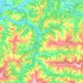
Naam: Topografische kaart Mieres, hoogte, reliëf.
Locatie: Mieres, Asturias, Spain (43.18111 -5.85553 43.28914 -5.62549)
Gemiddelde hoogte: 498 m
Minimale hoogte: 116 m
Maximale hoogte: 1.171 m
Andere topografische kaarten
Klik op een kaart om zijn topografie, zijn hoogte en zijn reliëf te bekijken.
Picos de Europa
The Picos de Europa ("Peaks of Europe", also the Picos) are a mountain range extending for about 20 km (12 mi), forming part of the Cantabrian Mountains in northern Spain. The range is situated in the Autonomous Communities of Asturias, Cantabria and Castile and León. The highest peak is Torre de Cerredo, at…
Gemiddelde hoogte: 2.290 m