
Topografische kaart Golden Gate Park
Interactieve kaart
Klik op de kaart om de hoogte weer te geven.
Over deze kaart
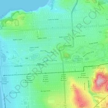
Naam: Topografische kaart Golden Gate Park, hoogte, reliëf.
Locatie: Golden Gate Park, San Francisco, California, United States (37.76414 -122.51087 37.77465 -122.45318)
Gemiddelde hoogte: 71 m
Minimale hoogte: -1 m
Maximale hoogte: 272 m
In the 1860s, San Franciscans began to feel the need for a spacious public park similar to Central Park, which was then taking shape in New York City. Golden Gate Park was carved out of unpromising sand and shore dunes that were known as the Outside Lands, in an unincorporated area west of San Francisco's then-current borders. In 1865, Frederick Law Olmsted proposed a plan for a park using native species suited for San Francisco's dry climate; however, the proposal was rejected in favor of a Central Park-style park needing extensive irrigation. Conceived ostensibly for recreation, the underlying purpose of the park was housing development and the westward expansion of the city. The tireless field engineer William Hammond Hall prepared a survey and topographic map of the park site in 1870 and became its commissioner in 1871. He was later named California's first state engineer and developed an integrated flood control system for the Sacramento Valley. The park drew its name from nearby Golden Gate Strait.
Andere topografische kaarten
Klik op een kaart om zijn topografie, zijn hoogte en zijn reliëf te bekijken.
San Francisco Bay Area
United States > California > San Francisco
San Francisco Bay Area, San Francisco, California, 94110, United States
Gemiddelde hoogte: 113 m
Presidio
United States > California > San Francisco
Presidio, San Francisco, California, 94129, United States
Gemiddelde hoogte: 38 m
Alcatraz Island
United States > California > San Francisco
Alcatraz Island, San Francisco, CAL Fire Northern Region, California, United States
Gemiddelde hoogte: 0 m
Sunnyside Playground
United States > California > San Francisco
Sunnyside Playground, San Francisco, California, United States
Gemiddelde hoogte: 117 m
Potrero Hill
United States > California > San Francisco
Potrero Hill, San Francisco, California, 94124, United States
Gemiddelde hoogte: 17 m
Alcatraz Island Lighthouse
United States > California > San Francisco
Alcatraz Island Lighthouse, West Road, San Francisco, California, 94123, United States
Gemiddelde hoogte: 0 m
Nob Hill
United States > California > San Francisco
Nob Hill, San Francisco, CAL Fire Northern Region, California, 94109, United States
Gemiddelde hoogte: 43 m
Fort Point
United States > California > San Francisco
Fort Point, Golden Gate Bridge East Sidewalk, San Francisco, CAL Fire Northern Region, California, 94129, United States
Gemiddelde hoogte: 10 m
South Park
United States > California > San Francisco
South Park, South Beach, San Francisco, CAL Fire Northern Region, California, United States
Gemiddelde hoogte: 10 m
Salesforce Park
United States > California > San Francisco
Salesforce Park, Transbay, San Francisco, CAL Fire Northern Region, California, United States
Gemiddelde hoogte: 16 m
Yerba Buena Island
United States > California > San Francisco
Yerba Buena Island, San Francisco, California, 94130, United States
Gemiddelde hoogte: 70 m