
Topografische kaart Belagavi
Interactieve kaart
Klik op de kaart om de hoogte weer te geven.
Over deze kaart
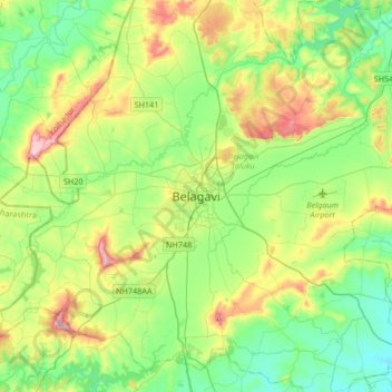
Naam: Topografische kaart Belagavi, hoogte, reliëf.
Gemiddelde hoogte: 760 m
Minimale hoogte: 644 m
Maximale hoogte: 1.018 m
Belgaum is located at 15°52′N 74°30′E / 15.87°N 74.5°E / 15.87; 74.5. It has an average elevation of 751 metres (2,464 feet). The city is in the northwestern parts of Karnataka and lies at the border of two states, Maharashtra and Goa on the western ghats (50 km (31 mi) from the Goa state border). It is one of the oldest towns in the state, lying 502 km (312 mi) from Bangalore, 500 km (310 mi) from Mumbai, 515 km (320 mi) from Hyderabad, and 600 km (370 mi) from Mysore. The district comprises 1278 villages with an area of 31,415 km2 (12,129 sq mi) and a population of around 4.8 million according to the census of 2011. Belgaum district is the biggest district of Karnataka. Situated near the foothills of the Sahyadri mountain range (Western Ghats) at an altitude of about 779 m (2,556 ft), 100 km (62 mi) from the Arabian Sea with the Markandeya river flowing nearby, Belgaum exhibits swift and kaleidoscopic changes in topography, vegetation and climate.
Andere topografische kaarten
Klik op een kaart om zijn topografie, zijn hoogte en zijn reliëf te bekijken.
Kinaye
India > Karnataka > Belagavi taluku
Kinaye, Belagavi taluku, Karnataka, 590014, India
Gemiddelde hoogte: 787 m
Hirebagevadi
India > Karnataka > Belagavi taluku > Hirebagevadi
Hirebagevadi, Belagavi taluku, Belgaum district, Karnataka, 591109, India
Gemiddelde hoogte: 692 m
Markandeya
India > Karnataka > Belagavi taluku
Markandeya, Belagavi taluku, Belgaum district, Karnataka, 591307, India
Gemiddelde hoogte: 736 m