
Topografische kaart Port Angeles
Klik op de kaart om de hoogte weer te geven.
Port Angeles
Port Angeles is characterized by a diverse and dramatic topography that reflects its unique geographic position on the Olympic Peninsula. Situated at approximately 72 feet above sea level, the city rises from the shores of the Strait of Juan de Fuca and is bordered by the Olympic Mountains to the south, which soar to elevations exceeding 7,000 feet. This mountainous backdrop is notable for its steep slopes and deep valleys, shaped by glacial activity and erosion. The surrounding landscape features a mixture of rugged terrain and lush forests, with numerous rivers and streams that traverse the area, enhancing its scenic beauty and providing habitats for local wildlife. Additionally, the coastline is marked by rocky shorelines and sandy beaches, creating a rich environment for both recreation and biodiversity.
Over deze kaart
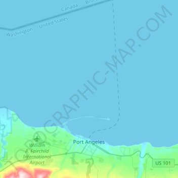
Naam: Topografische kaart Port Angeles, hoogte, reliëf.
Gemiddelde hoogte: 27 m
Minimale hoogte: -6 m
Maximale hoogte: 501 m
Andere topografische kaarten
Klik op een kaart om zijn topografie, zijn hoogte en zijn reliëf te bekijken.
Olympic Peninsula Gardens
United States > Washington > Clallam County > Sequim
Gemiddelde hoogte: 45 m