
Topografische kaart Six Mile Lake Provincial Park
Interactieve kaart
Klik op de kaart om de hoogte weer te geven.
Over deze kaart
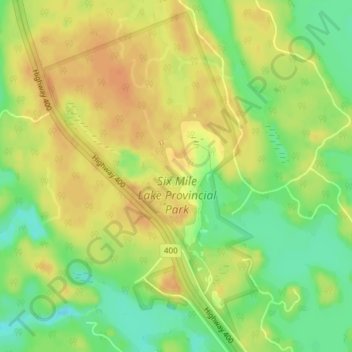
Naam: Topografische kaart Six Mile Lake Provincial Park, hoogte, reliëf.
Gemiddelde hoogte: 198 m
Minimale hoogte: 176 m
Maximale hoogte: 212 m
Andere topografische kaarten
Klik op een kaart om zijn topografie, zijn hoogte en zijn reliëf te bekijken.
Georgian Bay Islands National Park
Canada > Ontario > Georgian Bay
Georgian Bay Islands National Park, Georgian Bay, District Municipality of Muskoka, Muskoka District, Ontario, Canada
Gemiddelde hoogte: 179 m