
Topografische kaart Culebra
Interactieve kaart
Klik op de kaart om de hoogte weer te geven.
Over deze kaart
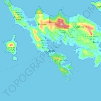
Naam: Topografische kaart Culebra, hoogte, reliëf.
Locatie: Culebra, Puerto Rico, 00775-0969, United States (18.26305 -65.34010 18.34305 -65.26010)
Gemiddelde hoogte: 16 m
Minimale hoogte: -3 m
Maximale hoogte: 188 m
Culebra is characterized by an irregular topography resulting in a long intricate shoreline. The island is approximately 7 by 5 miles (11 by 8 km). The coast is marked by cliffs, sandy coral beaches and mangrove forests. Inland, the tallest point on the island is Mount Resaca, with an elevation of 636 ft (193.9 m), followed by Balcón Hill, with an elevation of 545 ft (166.1 m).