
Topografische kaart Sagwara
Interactieve kaart
Klik op de kaart om de hoogte weer te geven.
Over deze kaart
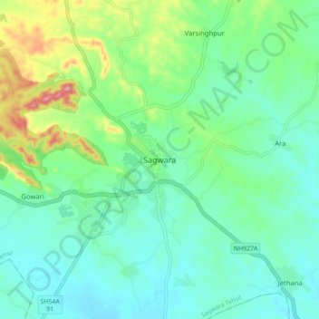
Naam: Topografische kaart Sagwara, hoogte, reliëf.
Gemiddelde hoogte: 177 m
Minimale hoogte: 138 m
Maximale hoogte: 291 m
Sagwara is located in the east-central Dungarpur district, in Sagwara Tehsil. It has an average elevation of 244 metres (801 ft). Sagwara is famous for its sculpture, marble carving, temple architecture and gold jewelry. It is a major trading hub for nearby villages.
Andere topografische kaarten
Klik op een kaart om zijn topografie, zijn hoogte en zijn reliëf te bekijken.
Kariyana
India > Rajasthan > Sagwara Tehsil
Kariyana, Sagwara Tehsil, Dungarpur District, Rajasthan, 314032, India
Gemiddelde hoogte: 167 m
Gowari
India > Rajasthan > Sagwara Tehsil
Gowari, Sagwara Tehsil, Dungarpur District, Rajasthan, India
Gemiddelde hoogte: 178 m
Mandav
India > Rajasthan > Sagwara Tehsil
Mandav, Sagwara Tehsil, Dungarpur District, Rajasthan, 314024, India
Gemiddelde hoogte: 238 m
Bheeloora
India > Rajasthan > Sagwara Tehsil > Bheeloora
Bheeloora, Sagwara Tehsil, Dungarpur, Rajasthan, 314031, India
Gemiddelde hoogte: 144 m