
Topografische kaart Cedros Island
Interactieve kaart
Klik op de kaart om de hoogte weer te geven.
Cedros Island
Cedros Island (Isla de Cedros, "island of cedars" in Spanish) is an island in the Pacific Ocean belonging to the state of Baja California, Mexico. The dry and rocky island had a population of 1,350 in 2005 and has an area of 348 square kilometres (134 sq mi) which includes the area of several small nearby islands. Cedros Island is mountainous, reaching a maximum elevation of 1,205 metres (3,953 ft). The economy is based on commercial fishing and salt production. Cedros has a distinctive flora and the traces of some of the earliest human beings in the New World. The ocean around the island is popular with sport fishermen.
Over deze kaart
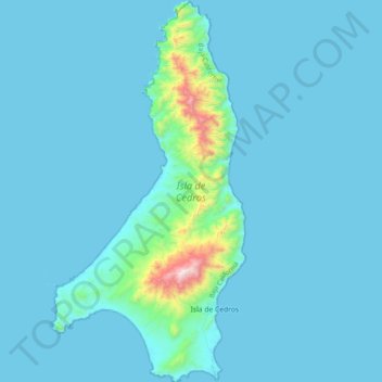
Naam: Topografische kaart Cedros Island, hoogte, reliëf.
Gemiddelde hoogte: 67 m
Minimale hoogte: -3 m
Maximale hoogte: 1.178 m
Andere topografische kaarten
Klik op een kaart om zijn topografie, zijn hoogte en zijn reliëf te bekijken.
San Miguel (Cíbolas de Mar)
Mexico > Baja California > Municipio de Ensenada > Ensenada
Gemiddelde hoogte: 57 m