
Topografische kaart Distrito Boquerón
Interactieve kaart
Klik op de kaart om de hoogte weer te geven.
Over deze kaart
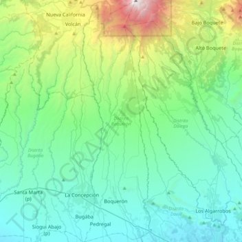
Naam: Topografische kaart Distrito Boquerón, hoogte, reliëf.
Locatie: Distrito Boquerón, Chiriquí, Panamá (8.44889 -82.62303 8.80893 -82.51897)
Gemiddelde hoogte: 706 m
Minimale hoogte: 29 m
Maximale hoogte: 3.422 m
Andere topografische kaarten
Klik op een kaart om zijn topografie, zijn hoogte en zijn reliëf te bekijken.
Alto Boquete
Panamá > Chiriquí > Distrito Boquete
Alto Boquete, Distrito Boquete, Chiriquí, Panamá
Gemiddelde hoogte: 713 m
Chiriquí
Panamá > Chiriquí > Distrito David
Chiriquí, Distrito David, Chiriquí, Panamá
Gemiddelde hoogte: 22 m