
Topografische kaart Lake City
Interactieve kaart
Klik op de kaart om de hoogte weer te geven.
Over deze kaart
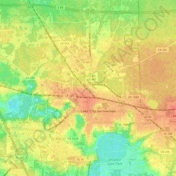
Naam: Topografische kaart Lake City, hoogte, reliëf.
Locatie: Lake City, Columbia County, Florida, United States (30.15517 -82.71055 30.24753 -82.60849)
Gemiddelde hoogte: 48 m
Minimale hoogte: 24 m
Maximale hoogte: 63 m
Andere topografische kaarten
Klik op een kaart om zijn topografie, zijn hoogte en zijn reliëf te bekijken.
Hollingsworth Bluff
United States > Florida > Columbia County
Hollingsworth Bluff, Columbia County, Florida, United States
Gemiddelde hoogte: 14 m
Fort White
United States > Florida > Columbia County
Fort White, Columbia County, Florida, 32038, United States
Gemiddelde hoogte: 22 m
Lake City
United States > Florida > Columbia County > Lake CIty
Lake City, Columbia County, Florida, 32026, United States
Gemiddelde hoogte: 48 m
Lake CIty
United States > Florida > Columbia County > Lake CIty
Lake CIty, Columbia County, Florida, United States
Gemiddelde hoogte: 48 m
Five Points
United States > Florida > Columbia County > Lake CIty
Five Points, Lake CIty, Columbia County, Florida, United States
Gemiddelde hoogte: 50 m