
Topografische kaart Smithfield
Interactieve kaart
Klik op de kaart om de hoogte weer te geven.
Over deze kaart
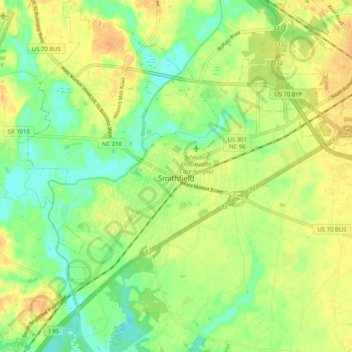
Naam: Topografische kaart Smithfield, hoogte, reliëf.
Locatie: Smithfield, Johnston County, North Carolina, United States (35.46740 -78.40351 35.55061 -78.30173)
Gemiddelde hoogte: 45 m
Minimale hoogte: 28 m
Maximale hoogte: 60 m
Andere topografische kaarten
Klik op een kaart om zijn topografie, zijn hoogte en zijn reliëf te bekijken.
Wilsons Mills
United States > North Carolina > Johnston County
Wilsons Mills, Johnston County, North Carolina, 27593, United States
Gemiddelde hoogte: 65 m
Clayton
United States > North Carolina > Johnston County
Clayton, Johnston County, North Carolina, United States
Gemiddelde hoogte: 81 m
Selma
United States > North Carolina > Johnston County
Selma, Johnston County, North Carolina, United States
Gemiddelde hoogte: 52 m
Willow Springs
United States > North Carolina > Johnston County > Willow Springs
Willow Springs, Johnston County, North Carolina, United States
Gemiddelde hoogte: 74 m
Country Estates
United States > North Carolina > Johnston County > Clayton > Country Estates
Country Estates, Clayton, Johnston County, North Carolina, 27520, United States
Gemiddelde hoogte: 89 m