
Topografische kaart Kohir
Interactieve kaart
Klik op de kaart om de hoogte weer te geven.
Over deze kaart
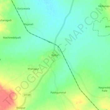
Naam: Topografische kaart Kohir, hoogte, reliëf.
Gemiddelde hoogte: 634 m
Minimale hoogte: 617 m
Maximale hoogte: 669 m
Kohir is located at 17°36′00″N 77°43′00″E / 17.6000°N 77.7167°E / 17.6000; 77.7167. It has an average elevation of 627 metres (2060 ft). It is 100 km from Hyderabad, 53 km from Bidar and 21 km from Zaheerabad.