
Topografische kaart Hawksbill
Interactieve kaart
Klik op de kaart om de hoogte weer te geven.
Over deze kaart
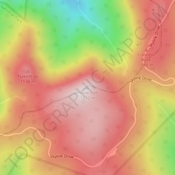
Naam: Topografische kaart Hawksbill, hoogte, reliëf.
Locatie: Hawksbill, Madison County, Virginia, United States (38.55531 -78.39519 38.55541 -78.39509)
Gemiddelde hoogte: 993 m
Minimale hoogte: 623 m
Maximale hoogte: 1.217 m
Hawksbill Mountain is a mountain with an elevation of 4,050 feet (1,234 m). Marking the border between Madison County and Page County in Virginia, the summit of Hawksbill Mountain is the highest point in Shenandoah National Park, as well as the highest point in both Madison and Page counties.
Andere topografische kaarten
Klik op een kaart om zijn topografie, zijn hoogte en zijn reliëf te bekijken.
Big Meadows
United States > Virginia > Madison County
Big Meadows, Madison County, Virginia, United States
Gemiddelde hoogte: 868 m