
Topografische kaart Nowy Targ
Interactieve kaart
Klik op de kaart om de hoogte weer te geven.
Over deze kaart
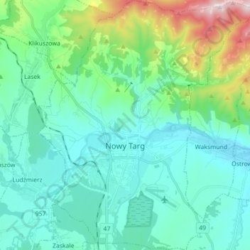
Naam: Topografische kaart Nowy Targ, hoogte, reliëf.
Gemiddelde hoogte: 679 m
Minimale hoogte: 567 m
Maximale hoogte: 1.135 m
According to the Köppen climate classification, Nowy Targ straddles the border of the Warm Summer Continental (Dfb) and Subarctic (Dfc) climates, with most of the city falling in the Dfb group. The Dfc climate is only found above 800 metres of elevation within Nowy Targ.