
Topografische kaart Kausani
Interactieve kaart
Klik op de kaart om de hoogte weer te geven.
Over deze kaart
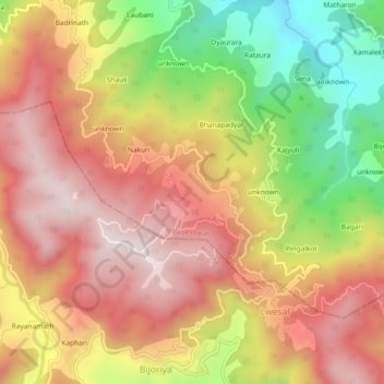
Naam: Topografische kaart Kausani, hoogte, reliëf.
Locatie: Kausani, Garud, Bageshwar, Uttarakhand, 263639, India (29.83397 79.57437 29.87397 79.61437)
Gemiddelde hoogte: 1.632 m
Minimale hoogte: 1.221 m
Maximale hoogte: 1.935 m