
Topografische kaart Fort Smith
Interactieve kaart
Klik op de kaart om de hoogte weer te geven.
Over deze kaart
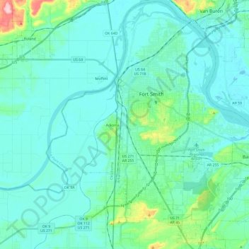
Naam: Topografische kaart Fort Smith, hoogte, reliëf.
Locatie: Fort Smith, Sebastian County, Arkansas, United States (35.25885 -94.43554 35.44982 -94.25286)
Gemiddelde hoogte: 140 m
Minimale hoogte: 114 m
Maximale hoogte: 266 m
The United States acquired the territory and large areas west of the Mississippi River from France in the Louisiana Purchase (1803). Soon after, the government sent the Pike Expedition (1806) to explore the areas along the Arkansas River. The US founded Fort Smith in 1817 as a military post. It was named after General Thomas Adams Smith (1781–1844), who commanded the United States Army Rifle Regiment in 1817, headquartered near St. Louis. General Smith had ordered Army topographical engineer Stephen H. Long (1784–1864) to find a suitable site on the Arkansas River for a fort. General Smith never visited the town or the forts that bore his name.
Andere topografische kaarten
Klik op een kaart om zijn topografie, zijn hoogte en zijn reliëf te bekijken.
Saw Mill
United States > Arkansas > Sebastian County > Fort Smith > Saw Mill
Saw Mill, Fort Smith, Sebastian County, Arkansas, 72916, United States
Gemiddelde hoogte: 167 m