
Topografische kaart Gotenba
Interactieve kaart
Klik op de kaart om de hoogte weer te geven.
Over deze kaart
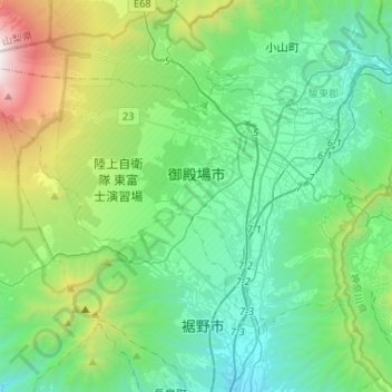
Naam: Topografische kaart Gotenba, hoogte, reliëf.
Locatie: Gotenba, Shizuoka Prefecture, Chubu Region, Japan (35.21482 138.73169 35.36197 138.99319)
Gemiddelde hoogte: 792 m
Minimale hoogte: 140 m
Maximale hoogte: 3.054 m
Gotemba is located in far eastern Shizuoka Prefecture at an altitude of 250–600 metres (820–1,970 ft). Mount Fuji is located to the west, and Mount Hakone to the east, with the Tanzawa Mountains to the north and Mount Ashitaka to the south. The area is noted for its numerous golf courses, with the Mitsui Sumitomo Visa Taiheiyo Masters taking place annually.
Andere topografische kaarten
Klik op een kaart om zijn topografie, zijn hoogte en zijn reliëf te bekijken.
Ozora
Ozora, Abashiri County, Okhotsk Subprefecture, Hokkaido Prefecture, Japan
Gemiddelde hoogte: 113 m
Biratori
Biratori, Saru County, Hidaka Subprefecture, Hokkaido Prefecture, Japan
Gemiddelde hoogte: 185 m
Toshima Island
Toshima Island, Maizuru, Kyoto Prefecture, Japan
Gemiddelde hoogte: 21 m
Niseko
Niseko, Abuta County, Shiribeshi Subprefecture, Hokkaido Prefecture, Japan
Gemiddelde hoogte: 339 m
Noto
Noto, Houshi County, Ishikawa Prefecture, Chubu Region, Japan
Gemiddelde hoogte: 56 m
Kitanakagusuku
Kitanakagusuku, Nakagami, Okinawa Prefecture, Japan
Gemiddelde hoogte: 59 m
Arita
Arita, Nishi-Matsuura County, Saga Prefecture, Japan
Gemiddelde hoogte: 184 m
Watarase Usuichi
Watarase Usuichi, Tochigi, Tochigi Prefecture, 374-0112, Japan
Gemiddelde hoogte: 18 m
Hakone
Hakone, Ashigarashimo County, Kanagawa Prefecture, Japan
Gemiddelde hoogte: 722 m
Saza
Saza, Kita-Matsuura County, Nagasaki Prefecture, 857-0322, Japan
Gemiddelde hoogte: 111 m
Sagara
Sagara, Kuma County, Kumamoto Prefecture, 868-0094, Japan
Gemiddelde hoogte: 422 m
Nakaniikawa County
Nakaniikawa County, Toyama Prefecture, Chubu Region, Japan
Gemiddelde hoogte: 665 m