
Topografische kaart Ward 43
Interactieve kaart
Klik op de kaart om de hoogte weer te geven.
Over deze kaart
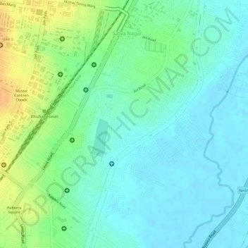
Naam: Topografische kaart Ward 43, hoogte, reliëf.
Gemiddelde hoogte: 28 m
Minimale hoogte: 15 m
Maximale hoogte: 51 m
Andere topografische kaarten
Klik op een kaart om zijn topografie, zijn hoogte en zijn reliëf te bekijken.
Ward 44
India > Odisha > Bhubaneswar (M.Corp.) > Bhubaneswar Municipal Corporation
Ward 44, South East Zone, Bhubaneswar Municipal Corporation, Bhubaneswar (M.Corp.), Khordha District, Odisha, India
Gemiddelde hoogte: 21 m