
Topografische kaart Cape Charles
Interactieve kaart
Klik op de kaart om de hoogte weer te geven.
Over deze kaart
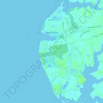
Naam: Topografische kaart Cape Charles, hoogte, reliëf.
Locatie: Cape Charles, Northampton County, Virginia, United States (37.23459 -76.02570 37.28207 -75.99172)
Gemiddelde hoogte: 2 m
Minimale hoogte: -6 m
Maximale hoogte: 17 m
Cape Charles lies on a peninsula and is surrounded by water on three sides. The town is situated directly on the Chesapeake Bay, bordered by King's Creek to the north and Old Plantation Creek to the south. The land in town is low lying and relatively flat, with the highest point of elevation at 15 feet, and a slope of less than 1%. Most of the developed land in town is between 5 and 10 feet in elevation.
Andere topografische kaarten
Klik op een kaart om zijn topografie, zijn hoogte en zijn reliëf te bekijken.
Oyster
United States > Virginia > Northampton County
Oyster, Northampton County, Virginia, 23316, United States
Gemiddelde hoogte: 4 m
Exmore
United States > Virginia > Northampton County > Exmore
Exmore, Northampton County, Virginia, United States
Gemiddelde hoogte: 8 m
Cheriton
United States > Virginia > Northampton County
Cheriton, Northampton County, Virginia, United States
Gemiddelde hoogte: 7 m