
Topografische kaart Kenton County
Interactieve kaart
Klik op de kaart om de hoogte weer te geven.
Over deze kaart
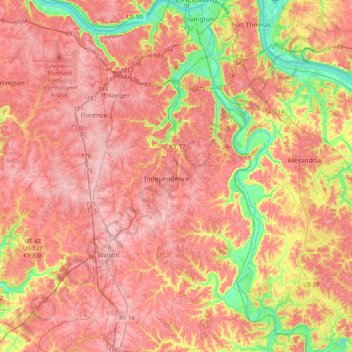
Naam: Topografische kaart Kenton County, hoogte, reliëf.
Locatie: Kenton County, Kentucky, United States (38.78969 -84.62370 39.09992 -84.41749)
Gemiddelde hoogte: 233 m
Minimale hoogte: 135 m
Maximale hoogte: 293 m
According to the United States Census Bureau, the county has a total area of 164 square miles (420 km2), of which 160 square miles (410 km2) is land and 4.1 square miles (11 km2) (2.5%) is water. The county is located at the confluence of the Licking River and Ohio River, in the outer Bluegrass area of the Bluegrass region of the state. The elevation in the county ranges from 455 feet (139 m) to 960 feet (293 m) above sea level.
Andere topografische kaarten
Klik op een kaart om zijn topografie, zijn hoogte en zijn reliëf te bekijken.
Lexington
United States > Kentucky > Lexington
Lexington, Fayette County, Kentucky, 40508, United States
Gemiddelde hoogte: 285 m
East Bernstadt
United States > Kentucky > Laurel County
East Bernstadt, Laurel County, Kentucky, United States
Gemiddelde hoogte: 367 m
Sandhill
United States > Kentucky > Muhlenberg County
Sandhill, Muhlenberg County, Kentucky, 42369, United States
Gemiddelde hoogte: 143 m
McDowell
United States > Kentucky > Floyd County
McDowell, Floyd County, Kentucky, 41647, United States
Gemiddelde hoogte: 324 m
Indian Hills Cherokee Section
United States > Kentucky > Jefferson County > Indian Hills
Indian Hills Cherokee Section, Indian Hills, Jefferson County, Kentucky, 40207, United States
Gemiddelde hoogte: 168 m
Morning View
United States > Kentucky > Kenton County
Morning View, Kenton County, Kentucky, 41063, United States
Gemiddelde hoogte: 192 m
Broad Bottom
United States > Kentucky > Pike County
Broad Bottom, Pike County, Kentucky, 41659, United States
Gemiddelde hoogte: 274 m
Louisville
United States > Kentucky > Jefferson County > Louisville
Louisville, Jefferson County, Kentucky, 40202-2923, United States
Gemiddelde hoogte: 180 m
Plumville
United States > Kentucky > Mason County
Plumville, Mason County, Kentucky, United States
Gemiddelde hoogte: 247 m
Lawrence County
Lawrence County, Kentucky, United States
Gemiddelde hoogte: 255 m
Carrollton
United States > Kentucky > Carroll County
Carrollton, Carroll County, Kentucky, United States
Gemiddelde hoogte: 170 m
Livingston County
Livingston County, Kentucky, United States
Gemiddelde hoogte: 131 m
Keaton
United States > Kentucky > Johnson County
Keaton, Johnson County, Kentucky, 41226, United States
Gemiddelde hoogte: 270 m
Owensboro
United States > Kentucky > Daviess County
Owensboro, Daviess County, Kentucky, United States
Gemiddelde hoogte: 123 m
Aboretum
United States > Kentucky > Calloway County > Murray
Aboretum, Murray, Calloway County, Kentucky, United States
Gemiddelde hoogte: 168 m
Edsel
United States > Kentucky > Elliott County
Edsel, Elliott County, Kentucky, United States
Gemiddelde hoogte: 277 m
Dunmor
United States > Kentucky > Muhlenberg County
Dunmor, Muhlenberg County, Kentucky, 42339, United States
Gemiddelde hoogte: 179 m
Villa Hills
United States > Kentucky > Kenton County
Villa Hills, Kenton County, Kentucky, United States
Gemiddelde hoogte: 224 m
Oak Grove
United States > Kentucky > Christian County
Oak Grove, Christian County, Kentucky, 42262, United States
Gemiddelde hoogte: 170 m
Muhlenberg County
Muhlenberg County, Kentucky, United States
Gemiddelde hoogte: 144 m
Burtonville
United States > Kentucky > Lewis County
Burtonville, Lewis County, Kentucky, United States
Gemiddelde hoogte: 254 m
Buster Hill
United States > Kentucky > Wayne County > Monticello
Buster Hill, Monticello, Wayne County, Kentucky, 42633, United States
Gemiddelde hoogte: 295 m
Limp
United States > Kentucky > Hardin County
Limp, Hardin County, Kentucky, United States
Gemiddelde hoogte: 211 m
Danville
United States > Kentucky > Boyle County
Danville, Boyle County, Kentucky, United States
Gemiddelde hoogte: 290 m
Elizabethtown
United States > Kentucky > Hardin County
Elizabethtown, Hardin County, Kentucky, 42701, United States
Gemiddelde hoogte: 241 m
Hindman
United States > Kentucky > Knott County
Hindman, Knott County, Kentucky, United States
Gemiddelde hoogte: 388 m
E.P. "Tom" Sawyer State Park
United States > Kentucky > Jefferson County > Louisville > Lakeland
E.P. "Tom" Sawyer State Park, Lakeland, Louisville, Jefferson County, Kentucky, United States
Gemiddelde hoogte: 209 m
Lebanon Junction
United States > Kentucky > Bullitt County
Lebanon Junction, Bullitt County, Kentucky, United States
Gemiddelde hoogte: 144 m
Gilbertsville
United States > Kentucky > Marshall County
Gilbertsville, Marshall County, Kentucky, United States
Gemiddelde hoogte: 104 m
Clark County
Clark County, Kentucky, 40391, United States
Gemiddelde hoogte: 273 m
Morehead
United States > Kentucky > Rowan County
Morehead, Rowan County, Kentucky, 40351, United States
Gemiddelde hoogte: 287 m
McConnell Springs
United States > Kentucky > Fayette County > Lexington
McConnell Springs, Lexington, Fayette County, Kentucky, United States
Gemiddelde hoogte: 287 m
Guthrie
United States > Kentucky > Todd County
Guthrie, Todd County, Kentucky, United States
Gemiddelde hoogte: 172 m
Maysville
United States > Kentucky > Mason County
Maysville, Mason County, Kentucky, 41056, United States
Gemiddelde hoogte: 236 m
Wilmore
United States > Kentucky > Jessamine County
Wilmore, Jessamine County, Kentucky, 40390, United States
Gemiddelde hoogte: 272 m
Dry Ridge
United States > Kentucky > Grant County
Dry Ridge, Grant County, Kentucky, United States
Gemiddelde hoogte: 274 m
Epperson
United States > Kentucky > McCracken County
Epperson, McCracken County, Kentucky, United States
Gemiddelde hoogte: 107 m
Hampton Manor
United States > Kentucky > Clark County > Winchester
Hampton Manor, Winchester, Clark County, Kentucky, 40391, United States
Gemiddelde hoogte: 297 m
Nicholasville
United States > Kentucky > Jessamine County
Nicholasville, Jessamine County, Kentucky, 40356, United States
Gemiddelde hoogte: 285 m
Eolia
United States > Kentucky > Letcher County
Eolia, Letcher County, Kentucky, 40826, United States
Gemiddelde hoogte: 612 m
William Whitley State Historic House
United States > Kentucky > Lincoln County
William Whitley State Historic House, Lincoln County, Kentucky, United States
Gemiddelde hoogte: 284 m
Crestwood
United States > Kentucky > Oldham County
Crestwood, Oldham County, Kentucky, United States
Gemiddelde hoogte: 223 m
West Point
United States > Kentucky > Hardin County
West Point, Hardin County, Kentucky, United States
Gemiddelde hoogte: 163 m
Taylor Mill
United States > Kentucky > Kenton County
Taylor Mill, Kenton County, Kentucky, 41015, United States
Gemiddelde hoogte: 211 m
Shakertown
United States > Kentucky > Mercer County
Shakertown, Mercer County, Kentucky, United States
Gemiddelde hoogte: 252 m
Weeksbury
United States > Kentucky > Floyd County
Weeksbury, Floyd County, Kentucky, 41669, United States
Gemiddelde hoogte: 487 m