
Doe een donatie
Rust jezelf uit voor je volgende avontuur:
Als Amazon-partner verdient deze site een commissie op in aanmerking komende aankopen, zonder extra kosten voor jou.
Topografische kaart Leavenworth
Klik op de kaart om de hoogte weer te geven.
Doe een donatie
Rust jezelf uit voor je volgende avontuur:
Als Amazon-partner verdient deze site een commissie op in aanmerking komende aankopen, zonder extra kosten voor jou.
Leavenworth
Leavenworth, Washington, is nestled at approximately 1,171 feet (357 meters) above sea level in the eastern foothills of the Cascade Mountains. The town is surrounded by rugged terrain, with steep slopes that rise sharply to elevations exceeding 5,000 feet (1,524 meters), and prominent peaks such as Icicle Ridge and Tumwater Mountain. These elevations create a dramatic contrast between the valley floor and the towering peaks, contributing to the area's breathtaking alpine scenery. The region's varied terrain includes dense forests, alpine meadows, and rugged cliffs, all interspersed with clear rivers and lakes. The Wenatchee River flows through the valley, adding to the area's natural beauty and providing a dynamic landscape shaped by both tectonic activity and glacial processes. This diverse landscape not only enhances the town's aesthetic appeal but also provides a wide range of outdoor recreational opportunities, from hiking and skiing to river rafting and wildlife viewing.
Doe een donatie
Rust jezelf uit voor je volgende avontuur:
Als Amazon-partner verdient deze site een commissie op in aanmerking komende aankopen, zonder extra kosten voor jou.
Over deze kaart
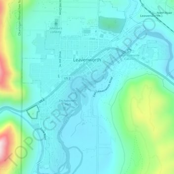
Naam: Topografische kaart Leavenworth, hoogte, reliëf.
Locatie: Leavenworth, Chelan County, Washington, United States (47.57509 -120.67945 47.60825 -120.64106)
Gemiddelde hoogte: 418 m
Minimale hoogte: 320 m
Maximale hoogte: 841 m
Doe een donatie
Rust jezelf uit voor je volgende avontuur:
Als Amazon-partner verdient deze site een commissie op in aanmerking komende aankopen, zonder extra kosten voor jou.
Andere topografische kaarten
Klik op een kaart om zijn topografie, zijn hoogte en zijn reliëf te bekijken.
Doe een donatie
Rust jezelf uit voor je volgende avontuur:
Als Amazon-partner verdient deze site een commissie op in aanmerking komende aankopen, zonder extra kosten voor jou.
Doe een donatie
Rust jezelf uit voor je volgende avontuur:
Als Amazon-partner verdient deze site een commissie op in aanmerking komende aankopen, zonder extra kosten voor jou.
Mount Stuart
United States > Washington > Chelan County
Mount Stuart is more notable for its local relief than for its absolute elevation. For example, the south face rises 5,000 feet (1,500 m) in just 2 horizontal miles (3.2 km). The northeast and northwest sides of the mountain exhibit similar steep relief. Due to its location away from higher peaks, Mount Stuart…
Gemiddelde hoogte: 2.109 m
Doe een donatie
Rust jezelf uit voor je volgende avontuur:
Als Amazon-partner verdient deze site een commissie op in aanmerking komende aankopen, zonder extra kosten voor jou.
Dragontail Peak
United States > Washington > Chelan County
The Alpine Lakes Wilderness features some of the most rugged topography in the Cascade Range with craggy peaks and ridges, deep glacial valleys, and granite walls spotted with over 700 mountain lakes. Geological events occurring many years ago created the diverse topography and drastic elevation changes over…
Gemiddelde hoogte: 2.235 m
Doe een donatie
Rust jezelf uit voor je volgende avontuur:
Als Amazon-partner verdient deze site een commissie op in aanmerking komende aankopen, zonder extra kosten voor jou.