
Topografische kaart Chiloquin
Interactieve kaart
Klik op de kaart om de hoogte weer te geven.
Over deze kaart
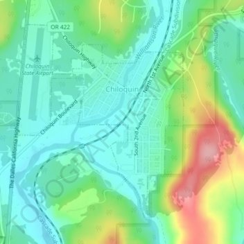
Naam: Topografische kaart Chiloquin, hoogte, reliëf.
Locatie: Chiloquin, Klamath County, Oregon, United States (42.56307 -121.88208 42.58478 -121.85693)
Gemiddelde hoogte: 1.302 m
Minimale hoogte: 1.262 m
Maximale hoogte: 1.395 m
Chiloquin is at an elevation of 4,180 feet (1,270 m) in Klamath County. The city is slightly east of U.S. Route 97 and slightly north of its intersection with Oregon Route 62. A short east–west highway, Oregon Route 422, links Route 97 at Chiloquin to Route 62 slightly south of Klamath Agency. By highway, Chiloquin is about 26 miles (42 km) north of Klamath Falls and 253 miles (407 km) south of Portland.
Andere topografische kaarten
Klik op een kaart om zijn topografie, zijn hoogte en zijn reliëf te bekijken.
Deepest point -592m
United States > Oregon > Klamath County
Deepest point -592m, Klamath County, Oregon, United States
Gemiddelde hoogte: 1.880 m
Link River
United States > Oregon > Klamath County > Klamath Falls
Link River, Klamath Falls, Klamath County, Oregon, United States
Gemiddelde hoogte: 1.304 m
Crater Lake
United States > Oregon > Klamath County
Crater Lake, Klamath County, Oregon, United States
Gemiddelde hoogte: 1.971 m
Willamette Pass
United States > Oregon > Klamath County
Willamette Pass, Klamath County, Oregon, United States
Gemiddelde hoogte: 1.605 m
Crater Lake National Park
United States > Oregon > Klamath County
Crater Lake National Park, Klamath County, Oregon, 97604, United States
Gemiddelde hoogte: 1.726 m
Klamath Falls
United States > Oregon > Klamath County
Klamath Falls, Klamath County, Oregon, 97601, United States
Gemiddelde hoogte: 1.312 m