
Topografische kaart Falkirk
Interactieve kaart
Klik op de kaart om de hoogte weer te geven.
Over deze kaart
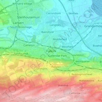
Naam: Topografische kaart Falkirk, hoogte, reliëf.
Locatie: Falkirk, Scotland, FK1 1ED, United Kingdom (55.95920 -3.82438 56.03920 -3.74438)
Gemiddelde hoogte: 69 m
Minimale hoogte: -1 m
Maximale hoogte: 207 m
Falkirk is located in an area of undulating topography between the Slamannan Plateau and the upper reaches of the Firth of Forth. The area to the north of Falkirk is part of the floodplain of the River Carron. Two tributaries of the River Carron - the East Burn and the West Burn flow through the town and form part of its natural drainage system. Falkirk sits at between 50 metres (164 ft) and 125 metres (410 ft) above sea level.