
Topografische kaart Szklary
Interactieve kaart
Klik op de kaart om de hoogte weer te geven.
Over deze kaart
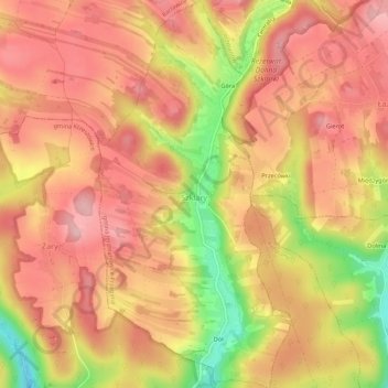
Naam: Topografische kaart Szklary, hoogte, reliëf.
Gemiddelde hoogte: 411 m
Minimale hoogte: 300 m
Maximale hoogte: 469 m
Andere topografische kaarten
Klik op een kaart om zijn topografie, zijn hoogte en zijn reliëf te bekijken.
Park Krajobrazowy Dolinki Krakowskie
Poland > Lesser Poland Voivodeship > Kraków County > Szklary
Park Krajobrazowy Dolinki Krakowskie, Szklary, gmina Jerzmanowice-Przeginia, Kraków County, Lesser Poland Voivodeship, 32-063, Poland
Gemiddelde hoogte: 341 m
Podzamcze
Poland > Lesser Poland Voivodeship > Kraków County > Korzkiew > Podzamcze
Podzamcze, Korzkiew, gmina Zielonki, Kraków County, Lesser Poland Voivodeship, Poland
Gemiddelde hoogte: 321 m
Bielańsko-Tyniecki Park Krajobrazowy
Poland > Lesser Poland Voivodeship > Kraków County > Krakow
Bielańsko-Tyniecki Park Krajobrazowy, Krakow, gmina Liszki, Kraków County, Lesser Poland Voivodeship, Poland
Gemiddelde hoogte: 239 m
Żbik
Poland > Lesser Poland Voivodeship > Kraków County > Krzeszowice
Żbik, Krzeszowice, gmina Krzeszowice, Kraków County, Lesser Poland Voivodeship, 32-065, Poland
Gemiddelde hoogte: 317 m
Tenczyński Park Krajobrazowy
Poland > Lesser Poland Voivodeship > Kraków County
Tenczyński Park Krajobrazowy, Kraków County, Lesser Poland Voivodeship, Poland
Gemiddelde hoogte: 308 m
Leszczynowa
Poland > Lesser Poland Voivodeship > Kraków County > Chrosna
Leszczynowa, Chrosna, gmina Liszki, Kraków County, Lesser Poland Voivodeship, Poland
Gemiddelde hoogte: 307 m
Kleszczów
Poland > Lesser Poland Voivodeship > Kraków County
Kleszczów, gmina Zabierzów, Kraków County, Lesser Poland Voivodeship, Poland
Gemiddelde hoogte: 309 m
Sułoszowa
Poland > Lesser Poland Voivodeship > Kraków County
Sułoszowa, gmina Sułoszowa, Kraków County, Lesser Poland Voivodeship, 32-045, Poland
Gemiddelde hoogte: 442 m
Werychów
Poland > Lesser Poland Voivodeship > Kraków County > Balice
Werychów, Balice, gmina Zabierzów, Kraków County, Lesser Poland Voivodeship, 31-083, Poland
Gemiddelde hoogte: 238 m
Siedlisko
Poland > Lesser Poland Voivodeship > Kraków County > Radziszów
Siedlisko, Radziszów, gmina Skawina, Kraków County, Lesser Poland Voivodeship, 32-052, Poland
Gemiddelde hoogte: 262 m
Czerna
Poland > Lesser Poland Voivodeship > Kraków County
Czerna, gmina Krzeszowice, Kraków County, Lesser Poland Voivodeship, Poland
Gemiddelde hoogte: 400 m
Słomniki
Poland > Lesser Poland Voivodeship > Kraków County > Słomniki
Słomniki, gmina Słomniki, Kraków County, Lesser Poland Voivodeship, 32-090, Poland
Gemiddelde hoogte: 250 m
Rudawa
Poland > Lesser Poland Voivodeship > Kraków County
Rudawa, Kraków County, Lesser Poland Voivodeship, 32-080, Poland
Gemiddelde hoogte: 262 m
Czułówek
Poland > Lesser Poland Voivodeship > Kraków County > Czułówek > Czułówek
Czułówek, gmina Czernichów, Kraków County, Lesser Poland Voivodeship, 32-061, Poland
Gemiddelde hoogte: 264 m
Balice
Poland > Lesser Poland Voivodeship > Kraków County > Balice
Balice, gmina Zabierzów, Kraków County, Lesser Poland Voivodeship, 32-083, Poland
Gemiddelde hoogte: 254 m
Maszyce
Poland > Lesser Poland Voivodeship > Kraków County
Maszyce, gmina Skała, Kraków County, Lesser Poland Voivodeship, Poland
Gemiddelde hoogte: 366 m
Chorowice
Poland > Lesser Poland Voivodeship > Kraków County
Chorowice, gmina Mogilany, Kraków County, Lesser Poland Voivodeship, Poland
Gemiddelde hoogte: 314 m
Radwanowice
Poland > Lesser Poland Voivodeship > Kraków County
Radwanowice, gmina Zabierzów, Kraków County, Lesser Poland Voivodeship, Poland
Gemiddelde hoogte: 329 m