
Topografische kaart Lawrence
Interactieve kaart
Klik op de kaart om de hoogte weer te geven.
Lawrence
Lawrence is located at coordinates 38.9716689, -95.2352501 in the state of Kansas, approximately 25 miles (40 kilometers) east of Topeka, and 35 mi (56 km) west of Kansas City, Kansas. Though Lawrence has a designated elevation of 866 feet (264 m), the highest elevation is Mount Oread on the University of Kansas campus with an elevation of 1,020 feet (310 m).
Over deze kaart
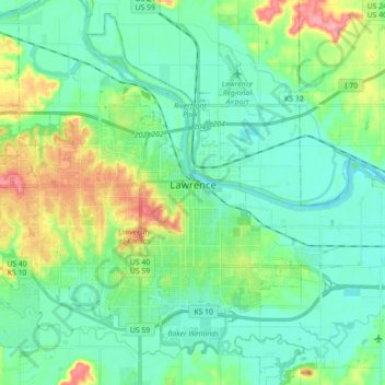
Naam: Topografische kaart Lawrence, hoogte, reliëf.
Locatie: Lawrence, Douglas County, Kansas, United States (38.90447 -95.34454 39.03350 -95.16662)
Gemiddelde hoogte: 265 m
Minimale hoogte: 241 m
Maximale hoogte: 333 m
Andere topografische kaarten
Klik op een kaart om zijn topografie, zijn hoogte en zijn reliëf te bekijken.
Lawrence
United States > Kansas > Douglas County > Lawrence
Downtown Lawrence is located at 38°58′18″N 95°14′7″W / 38.97167°N 95.23528°W / 38.97167; -95.23528 (38.959902, −95.253199), approximately 25 miles (40 kilometers) east of Topeka, and 35 mi (56 km) west of Kansas City, Kansas. Though Lawrence has a designated elevation of 866 feet (264…
Gemiddelde hoogte: 283 m