
Topografische kaart Rapids City
Interactieve kaart
Klik op de kaart om de hoogte weer te geven.
Over deze kaart
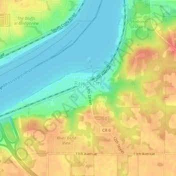
Naam: Topografische kaart Rapids City, hoogte, reliëf.
Gemiddelde hoogte: 196 m
Minimale hoogte: 171 m
Maximale hoogte: 223 m
Andere topografische kaarten
Klik op een kaart om zijn topografie, zijn hoogte en zijn reliëf te bekijken.
Coal Valley
United States > Illinois > Rock Island County
Coal Valley, Rock Island County, Illinois, 61240, United States
Gemiddelde hoogte: 198 m
Carbon Cliff
United States > Illinois > Rock Island County
Carbon Cliff, Rock Island County, Illinois, 61239, United States
Gemiddelde hoogte: 188 m
Port Byron
United States > Illinois > Rock Island County
Port Byron, Rock Island County, Illinois, United States
Gemiddelde hoogte: 202 m
Moline
United States > Illinois > Rock Island County
Moline, Rock Island County, Illinois, 61265, United States
Gemiddelde hoogte: 193 m
Milan
United States > Illinois > Rock Island County
Milan, Rock Island County, Illinois, 61624, United States
Gemiddelde hoogte: 192 m
Moline
United States > Illinois > Rock Island County > Moline
Moline, Rock Island County, Illinois, 61265, United States
Gemiddelde hoogte: 210 m
Andalusia
United States > Illinois > Rock Island County > Andalusia
Andalusia, Rock Island County, Illinois, 61232, United States
Gemiddelde hoogte: 186 m
East Moline
United States > Illinois > Rock Island County
East Moline, Rock Island County, Illinois, United States
Gemiddelde hoogte: 191 m
Oak Grove
United States > Illinois > Rock Island County
Oak Grove, Rock Island County, Illinois, United States
Gemiddelde hoogte: 217 m