
Topografische kaart Union Canal
Interactieve kaart
Klik op de kaart om de hoogte weer te geven.
Over deze kaart
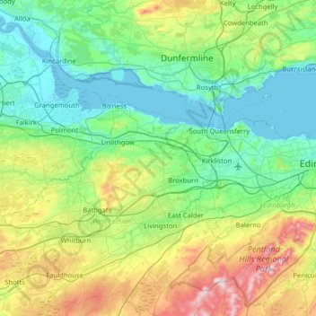
Naam: Topografische kaart Union Canal, hoogte, reliëf.
Locatie: Union Canal, West Lothian, Schotland, EH11 1AS, VK (55.91628 -3.84183 56.00172 -3.20835)
Gemiddelde hoogte: 136 m
Minimale hoogte: -3 m
Maximale hoogte: 564 m
Andere topografische kaarten
Klik op een kaart om zijn topografie, zijn hoogte en zijn reliëf te bekijken.
Fort William
VK > Schotland > Fort William
Fort William, Highland, Schotland, PH33 6DH, VK
Gemiddelde hoogte: 122 m
Forth and Clyde Canal
Forth and Clyde Canal, East Dunbartonshire, Schotland, G81 1QA, VK
Gemiddelde hoogte: 130 m
Caledonian Canal
Caledonian Canal, Highland, Schotland, IV3 8RE, VK
Gemiddelde hoogte: 420 m
Linga
VK > Schotland > South Garth
Linga, South Garth, Shetland Islands, Schotland, VK
Gemiddelde hoogte: 7 m
Greenbraehead
VK > Schotland > Greenbraehead
Greenbraehead, Scottish Borders, Schotland, TD9 9SW, VK
Gemiddelde hoogte: 187 m