
Topografische kaart Zhangjiakou
Interactieve kaart
Klik op de kaart om de hoogte weer te geven.
Zhangjiakou
Lying in between the Mongolian Plateau and the North China Plain, Zhangjiakou has a somewhat rugged topography characterized by high mountains, deep valleys, and rocky pathways. As a result, it serves as a perfect natural screen for Beijing, which has made it a strategic priority militarily since ancient times. It is called "The Gateway to Beijing" and "The Mountain City beyond the Great Wall". The grand Yan Mountain, the towering Taihang Mountain, the vast grasslands, and the meandering Sangyang River converge here. The city government has regarded tourism as a major driving force of the city's economy and continues to develop the industry.
Over deze kaart
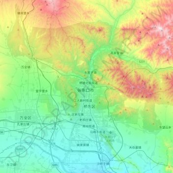
Naam: Topografische kaart Zhangjiakou, hoogte, reliëf.
Gemiddelde hoogte: 959 m
Minimale hoogte: 633 m
Maximale hoogte: 1.764 m
Andere topografische kaarten
Klik op een kaart om zijn topografie, zijn hoogte en zijn reliëf te bekijken.
Huailai County
China > Hebei > Zhangjiakou
Huailai County has a monsoon-influenced, continental semi-arid climate (Köppen BSk), with cold, dry, and windy winters and hot, humid summers, with temperatures slightly warmer than Zhangjiakou due to the more southerly location but still significantly cooler than in Beijing due to the high elevation. The…
Gemiddelde hoogte: 840 m