
Topografische kaart Sugar Land
Interactieve kaart
Klik op de kaart om de hoogte weer te geven.
Over deze kaart
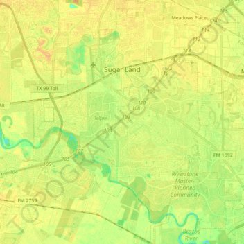
Naam: Topografische kaart Sugar Land, hoogte, reliëf.
Locatie: Sugar Land, Fort Bend County, Texas, United States (29.51252 -95.69811 29.66187 -95.58050)
Gemiddelde hoogte: 24 m
Minimale hoogte: 8 m
Maximale hoogte: 33 m
Sugar Land is located in northeast Fort Bend County, 20 miles (32 km) southwest of downtown Houston. It is bordered by Houston to the northeast, and by Stafford, Missouri City, and Meadows Place to the east. According to the United States Census Bureau, the city of Sugar Land has a total area of 34.0 square miles (88.1 km2), of which 32.4 square miles (83.9 km2) are land and 1.6 square miles (4.2 km2), or 4.82%, are covered by water. The elevation of most of the city is between 70 and 90 feet (21 and 27 m) above sea level. The elevation of Sugar Land Regional Airport (SGR) is 82 feet (25 m).
Andere topografische kaarten
Klik op een kaart om zijn topografie, zijn hoogte en zijn reliëf te bekijken.
Fulshear
United States > Texas > Fort Bend County
Fulshear, Fort Bend County, Texas, United States
Gemiddelde hoogte: 37 m
Sienna (Brazos River) Park
United States > Texas > Fort Bend County > Missouri City
Sienna (Brazos River) Park, Missouri City, Fort Bend County, Texas, 77459, United States
Gemiddelde hoogte: 20 m
Dewalt
United States > Texas > Fort Bend County > Missouri City
Dewalt, Missouri City, Fort Bend County, Texas, 77459, United States
Gemiddelde hoogte: 22 m
Thompsons
United States > Texas > Fort Bend County
Thompsons, Fort Bend County, Texas, United States
Gemiddelde hoogte: 22 m
Arcola
United States > Texas > Fort Bend County
Arcola, Fort Bend County, Texas, United States
Gemiddelde hoogte: 20 m
Katy
United States > Texas > Fort Bend County
Katy, Fort Bend County, Texas, United States
Gemiddelde hoogte: 44 m
Katy
United States > Texas > Fort Bend County > Katy > Katy
Katy, Fort Bend County, Texas, 77493, United States
Gemiddelde hoogte: 43 m
Duke
United States > Texas > Fort Bend County > Arcola > Duke
Duke, Arcola, Fort Bend County, Texas, 77545, United States
Gemiddelde hoogte: 20 m
Weston Lakes
United States > Texas > Fort Bend County > Weston Lakes
Weston Lakes, Fort Bend County, Texas, United States
Gemiddelde hoogte: 34 m
Richmond
United States > Texas > Fort Bend County > Richmond > Richmond
Richmond, Fort Bend County, Texas, 44769, United States
Gemiddelde hoogte: 27 m
Needville
United States > Texas > Fort Bend County > Needville > Needville
Needville, Fort Bend County, Texas, 77461, United States
Gemiddelde hoogte: 27 m
Lake D
United States > Texas > Fort Bend County
Lake D, Avalon at Seven Meadows, Fort Bend County, Texas, United States
Gemiddelde hoogte: 35 m
Needville
United States > Texas > Fort Bend County
Needville, Fort Bend County, Texas, United States
Gemiddelde hoogte: 28 m
Trammels
United States > Texas > Fort Bend County > Missouri City > Trammels
Trammels, Missouri City, Fort Bend County, Texas, 77459, United States
Gemiddelde hoogte: 22 m
Rosenberg
United States > Texas > Fort Bend County
Rosenberg, Fort Bend County, Texas, 77471, United States
Gemiddelde hoogte: 28 m
Orchard
United States > Texas > Fort Bend County > Orchard
Orchard, Fort Bend County, Texas, 77464, United States
Gemiddelde hoogte: 38 m