
Topografische kaart Hokianga Harbour
Interactieve kaart
Klik op de kaart om de hoogte weer te geven.
Over deze kaart
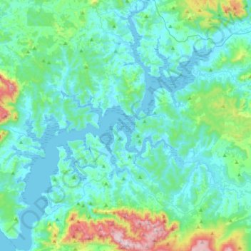
Naam: Topografische kaart Hokianga Harbour, hoogte, reliëf.
Gemiddelde hoogte: 113 m
Minimale hoogte: -1 m
Maximale hoogte: 755 m
Andere topografische kaarten
Klik op een kaart om zijn topografie, zijn hoogte en zijn reliëf te bekijken.
Whatuwhiwhi
New Zealand > Far North District > Te Hiku Community > Whatuwhiwhi
Whatuwhiwhi, Te Hiku Community, Far North District, Northland, New Zealand
Gemiddelde hoogte: 18 m
Whakawhiti Stream
New Zealand > Far North District > Bay of Islands-Whangaroa Community > Manawaora
Whakawhiti Stream, Manawaora, Bay of Islands-Whangaroa Community, Far North District, Northland, New Zealand
Gemiddelde hoogte: 58 m