
Topografische kaart Peerless Lake
Interactieve kaart
Klik op de kaart om de hoogte weer te geven.
Over deze kaart
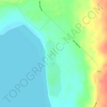
Naam: Topografische kaart Peerless Lake, hoogte, reliëf.
Gemiddelde hoogte: 703 m
Minimale hoogte: 687 m
Maximale hoogte: 745 m
Peerless Lake is an unincorporated community in northern Alberta, Canada. It is located on the northeastern shore of Peerless Lake, approximately 70 kilometres (43 mi) northeast of Red Earth Creek, and has an elevation of 695 metres (2,280 ft).
Andere topografische kaarten
Klik op een kaart om zijn topografie, zijn hoogte en zijn reliëf te bekijken.
Calling Lake
Canada > Alberta > Municipal District of Opportunity > Calling Lake
Calling Lake, Municipal District of Opportunity, Alberta, T0G 0K0, Canada
Gemiddelde hoogte: 609 m
Red Earth Creek
Canada > Alberta > Municipal District of Opportunity > Red Earth Creek
Red Earth Creek, Municipal District of Opportunity, Alberta, T0G 1X0, Canada
Gemiddelde hoogte: 549 m
Wabasca-Desmarais
Canada > Alberta > Municipal District of Opportunity > Wabasca-Desmarais
Wabasca-Desmarais, Municipal District of Opportunity, Alberta, T0G 2K0, Canada
Gemiddelde hoogte: 556 m