
Topografische kaart Trento
Interactieve kaart
Klik op de kaart om de hoogte weer te geven.
Over deze kaart
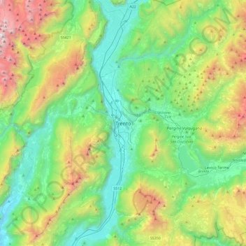
Naam: Topografische kaart Trento, hoogte, reliëf.
Gemiddelde hoogte: 970 m
Minimale hoogte: 93 m
Maximale hoogte: 3.117 m
Trento has a humid subtropical-continental climate (Cfa-Dfa) through most of its populated areas according to the Köppen climate classification. Boroughs at higher elevation like Viote have a colder alpine climate (Dw). Monthly average temperatures range between 1.6 °C (January) and 23.4 °C (July). Annual precipitation exceed 900 mm spread out on an average of 87 days, with peaks in late spring (May–June, 90 mm monthly average in 9–10 rain days) and autumn (October–November: 100–110 mm monthly average in 7–8 days), and lows in winter (January–February, 30–40 mm monthly average in 3–4 rain days).
Andere topografische kaarten
Klik op een kaart om zijn topografie, zijn hoogte en zijn reliëf te bekijken.
Roncafort
Italy > Trentino-Alto Adige/Südtirol > Provincia di Trento > Trento
Roncafort, Trento, Territorio Val d'Adige, Provincia di Trento, Trentino-Alto Adige/Südtirol, 38121, Italy
Gemiddelde hoogte: 341 m