
Topografische kaart Santa Martha
Interactieve kaart
Klik op de kaart om de hoogte weer te geven.
Over deze kaart
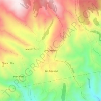
Naam: Topografische kaart Santa Martha, hoogte, reliëf.
Locatie: Santa Martha, San Gabriel, Montúfar, Carchi, 040201, Ecuador (0.61850 -77.86121 0.65850 -77.82121)
Gemiddelde hoogte: 3.213 m
Minimale hoogte: 2.895 m
Maximale hoogte: 3.513 m