Geolokaliseren

Topografische kaart Victoria

Klik op de kaart om de hoogte weer te geven.

Victoria

Victoria is a city and the county seat of Victoria County, Texas. The population was 65,534 as of the 2020 census. The three counties of the Victoria Metropolitan Statistical Area had a population of 111,163 as of the 2000 census. Its elevation is 95 ft (29 m).

Wikipedia (CC-BY-SA 3.0)

Over deze kaart

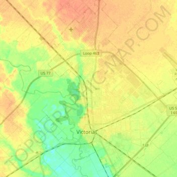
Naam: Topografische kaart Victoria, hoogte, reliëf.

Locatie: Victoria, Victoria County, Texas, United States (28.76331 -97.05143 28.90575 -96.90027)

Gemiddelde hoogte: 30 m

Minimale hoogte: 11 m

Maximale hoogte: 45 m

Andere topografische kaarten

Klik op een kaart om zijn topografie, zijn hoogte en zijn reliëf te bekijken.

Kemper City

United States > Texas > Victoria County

Gemiddelde hoogte: 30 m

Placedo

United States > Texas > Victoria County

Gemiddelde hoogte: 17 m

Rust jezelf uit voor je volgende avontuur:

🧥Softshell Jassen - Winddicht en waterafstotend voor actieve sporten
🗺️Topografische Kaarten - Gedetailleerde topografische kaarten voor wandelen en oriëntatie
🍴Camping Bestekset - Lichtgewicht en herbruikbaar servies
🚗Auto Navigatie GPS - Vind altijd de weg naar je startpunt
🧗Trekkingstokken - Stokken voor extra stabiliteit tijdens wandelen

Als Amazon-partner verdient deze site een commissie op in aanmerking komende aankopen, zonder extra kosten voor jou.