
Topografische kaart Brownville
Interactieve kaart
Klik op de kaart om de hoogte weer te geven.
Over deze kaart
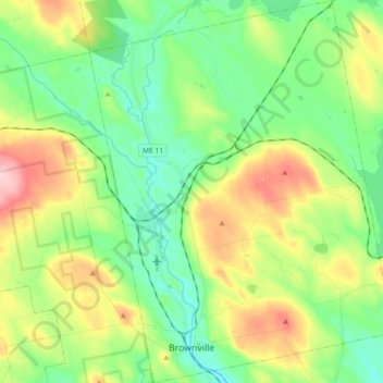
Naam: Topografische kaart Brownville, hoogte, reliëf.
Locatie: Brownville, Piscataquis County, Maine, 04414, United States (45.29545 -69.08237 45.42310 -68.93808)
Gemiddelde hoogte: 160 m
Minimale hoogte: 95 m
Maximale hoogte: 285 m
Andere topografische kaarten
Klik op een kaart om zijn topografie, zijn hoogte en zijn reliëf te bekijken.
Monson
United States > Maine > Piscataquis County
Monson, Piscataquis County, Maine, 04464, United States
Gemiddelde hoogte: 250 m
Wellington
United States > Maine > Piscataquis County
Wellington, Piscataquis County, Maine, United States
Gemiddelde hoogte: 257 m
Sebec
United States > Maine > Piscataquis County
Sebec, Piscataquis County, Maine, 04481, United States
Gemiddelde hoogte: 139 m
Rainbow Mountain
United States > Maine > Piscataquis County
Rainbow Mountain, Piscataquis County, Maine, United States
Gemiddelde hoogte: 394 m
Dover-Foxcroft
United States > Maine > Piscataquis County
Dover-Foxcroft, Piscataquis County, Maine, 04426, United States
Gemiddelde hoogte: 155 m
Guilford
United States > Maine > Piscataquis County > Guilford
Guilford, Piscataquis County, Maine, 04443, United States
Gemiddelde hoogte: 175 m
Parkman
United States > Maine > Piscataquis County > Parkman
Parkman, Piscataquis County, Maine, 04443, United States
Gemiddelde hoogte: 180 m